Appreciating the Remaining Rock Art & Lamenting Their Impending Loss (Part 2)

In this installment, the rock art introduced here along the Indus River near Tharpan. From Chilas, driving east on the Karakorum Highway, cross the bridge across the Indus River, and then follow the road called Tharpan Road, is where these rocks are located. Since this area of the river is very wide, the rock paintings remain over such a large area, and the rocks there are huge, so there are various rock paintings that have remained here.

Rock art depicting a pagoda

It only speculation, but it is thought that this was a large gathering place for people to cross the Indus River because the riverbank is so wide. It seems that many kinds of people of different backgrounds, may have gathered here. Since many were Buddhists, there are many rock paintings related to Buddhism, and there are still many large and magnificent pagoda carved with sharp, straight lines which remain.

Tibetan pagodas depicted with flags at the top

Many of the depictions of Buddha were drawn only using lines, and delicate decorations were rarely seen.

A statue holding the beads in his left hand

The rock paintings other than those related to Buddhism were all spectacular and very interesting as well.

A person with something like a balance

This is a person who has something like a balance next to a pagoda. I wonder, is it depicting the laborer who built the pagoda?

Ibex and circles

This painting depicts an ibex and a sun-like circle. According to the archaeologist’s guide, this circle depicts a “circular trap” used for hunting. Perhaps because it was a large gathering area for various ethnic groups, there are still some outstanding statues left in the area.

In the photo below, there is a person wearing a Persian costume.

A person wearing a Persian costume

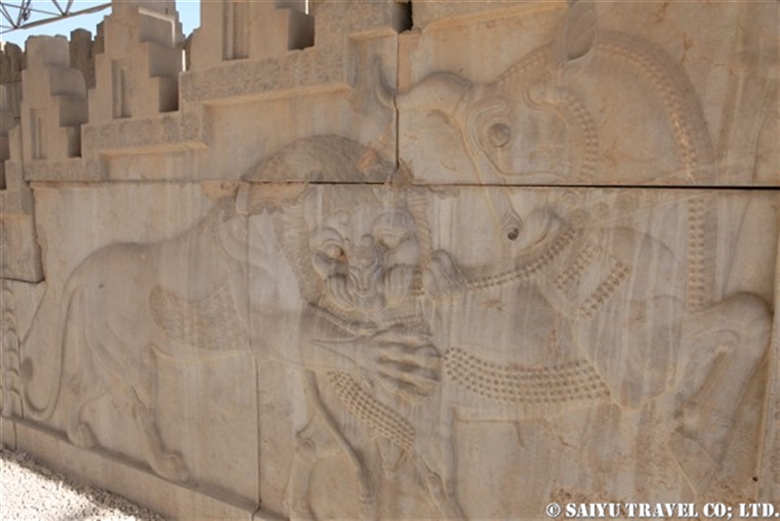
There were also rock paintings of animals drawn in the Persian style.

Animals drawn in the Persian style

In the designs of Persepolis, it is comment that the eyes of the animals are drawn with large circles.

The Apadana, lion and bull in relief, Persepolis

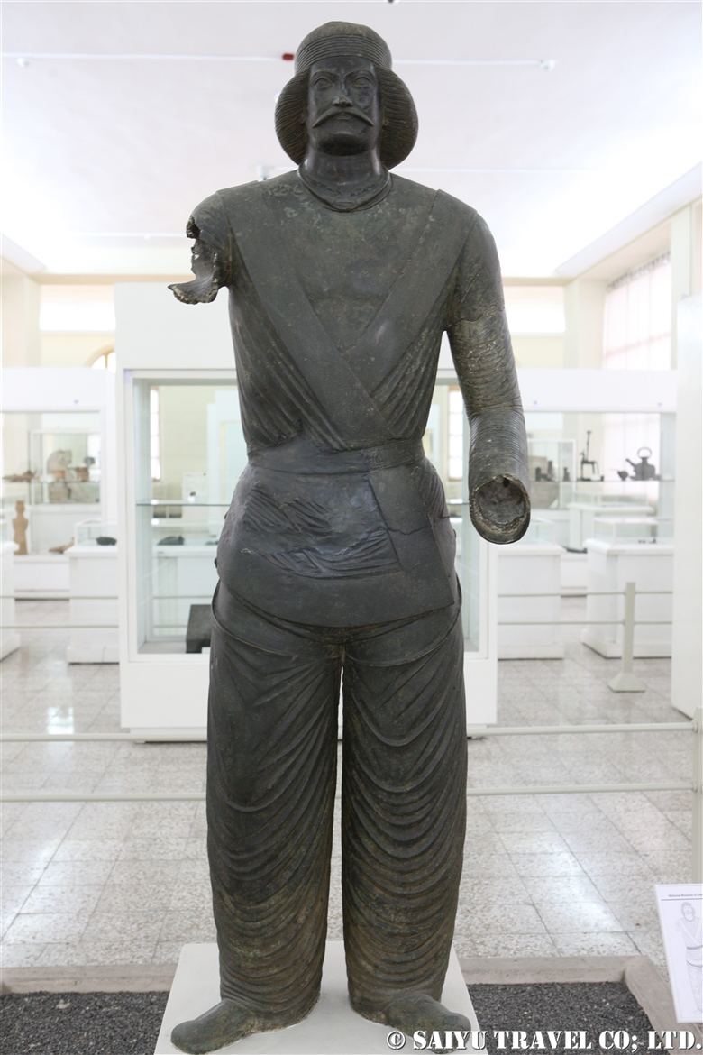
And below, the art that caught my interest in Tarpan was the image of a person who might be a Parthian.

A person who seems to be a Parthian

The Parthian Empire, which originated since the 3rd century BC, in what is now Turkmenistan and dominated West Asia, was split around 20 AD at the end of its reign. It was split into the Indo-Parthian by King Gondophares. This Indo-Parthian, which was once the capital of Taxila, was also active in the Indus River. Below is a statue of the Parthians in the Tehran Archaeological Museum. The appearance of the person wearing something like a helmet with a brim is common to see in the rock carvings.

A Parthian statue at the Archaeological Museum in Tehran

Once again in this figure, the person holds the hunted animal in the right hand and a sword in the left hand. It is a typical kind of design that was commonly seen for long time in West Asia.

Bronze plate from the Tehran archeological museum

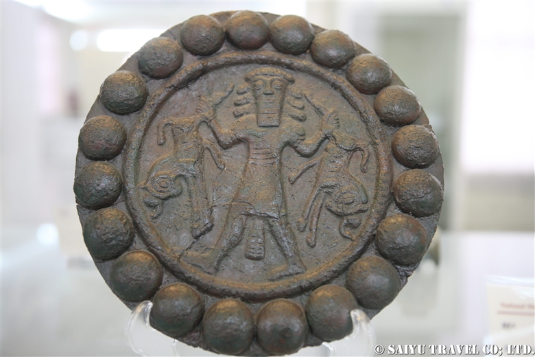
In this photo, a copper plate from the period 1000 BC, was excavated in the Azerbaijan region of the Tehran Archaeological Museum. A person stands in the center, holding up their hunted prey in both hands. It is also the prototype of the work “Renjumon” in which 20 small circles surround a large circle design.

Artifacts from Jiroft in the collection of the Tehran Archaeological Museum

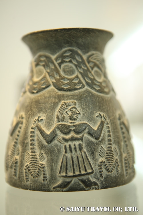
This photo is of an item that is also from the Bronze Age, the Jiroft culture, as seen in the Tehran Archaeological Museum. It is a soapstone vessel. The figure holds up huge scorpions, similarly, in both hands. I was very surprised that such designs and from different era designs are reflected in so many similar ways on the carvings in the rocks, along the Indus River.

The following picture is of the Parthian-carved rock, taken at a distance.

Rock with various carvings, masterpiece of Tharpan

In the lower center area of the photo, depicts the Parthians and the Persian style of drawing the animals are on the left, while the Buddha and four servants are carved to the right of the Parthians.

The Buddha and his four followers

Buddhism was also practiced in Parthian India, which is roughly the same period when these rock paintings were made. The fact that such various ethnic groups, religious icons, and animals all drawn in various styles, on the same rocks, tells us that this Tarpan was a great gathering place for the diverse people passing through. This is proof which embodies the significance of the Silk Road. I just can’t help but be overwhelmed with sorrow, to think that this place will sink to the bottom of the lake once the dam is completed.


Photo & text : Koji YAMADA

Visit : Nov 2021, Tharpan, Gilgit-Baltistan

Category : - the Karakoram Highway > ◆ Gilgit-Baltistan > - Indus river bank > ◇ Rock carvings / Petroglyph > ◇ Heritage of Pakistan
Tag : , , , , , , , , , , , , , , , ,

Appreciating the Remaining Rock Art & Lamenting Their Impending Loss (Part 1) Meandering Along the Karakorum Highway

I will introduce photos of the rock paintings I came across during my November 2021 visit, traveling along the Indus River. This blog will be broken up into several parts to cover the many different things I saw.

~~~~~~~~

In northern Pakistan, on the banks of the Indus River -from Shatial to Hunza, there are said to be more than 50,000 historic rock paintings that remain. These rock paintings mark the places where travelers crossed the Indus River, as they traveled along the Silk Road. When the Indus River waters were too precarious, travelers were forced to wait on the banks until the water levels fell enough to be able to make a safe crossing. While they waited, these carvings in the rocks were made by the various travelers, pilgrims, and merchants who were from all over. Most of the themes of the pictures relate to Buddhist traditions, but there are various motifs of animals (such as Ibex ,snow leopard) carved perhaps before Buddhism passed through this area. There are various ethnic groups represented based on the written languages as well, such as Kharosthi, Sogdian and Brahmi engraved.

A  bridge crossing over the Indus River

A modern bridge crossing over the Indus RiverWith most of the regular sightseeing tours being lead to Hunza and in this area, due to strict travel restrictions on the times allowed between destinations, you cannot take much time to make stops to see the rock art along the Karakorum Highway, as you could in the past. Last year, I made a research tour in November, taking time to stay in Chilas for a few nights, allowing me time to take leisurely tours of the riverbank to inspect and record the rock art I saw.

I was so shocked that there were so many rock paintings along the Karakorum Highway, places that I had so many times before, usually only passed on the road, without a thought. These photos were taken at Hudur, which is about 20 minutes west of Chilas along the Karakorum Highway.

Rock art of a pagoda with the flags fluttering in the wind

There are many places outside of Hudur where you can see many pagodas depicted in the rock art, probably made during the Kushan Dynasty in the height of Buddhism being spread across many different regions, and the various people who came from all over, as they travelled along the Silk Road.

A person reaching out with both hands, holding objects

A person holding a piece of armor in his left hand and a hunted animal in his right hand. This type of design, in which a person is drawn facing straight forward with the objects held in both hands held high, is one that has long been used in West Asia.In Gichi, just 10 minutes east of Hudur, there were many rock paintings of pagodas. Perhaps this is because many Buddhists stayed there, or because these relics were left untouched in the area.

Rock art of a pagoda that remains in Gichi-1.

In Oshibat, located about 10 minutes further east of Gichi, as soon as you get off the bus, you can see rock art scattered here and there. There were many there, but each one was very interesting and aroused my curiosity.

Rock art with an ibex image on the lower right side

On the lower right side you will clearly see the long-horned Ibex, and then to the left side, perhaps a hunter who is chasing it, looking very dynamic and looks like they are running.

Rock art with handprints and footprints

I’m not sure if it’s out of pure boredom, just waiting for the river water to go down, perhaps it is an old type of graffiti being carved, or perhaps it has a more mystical meaning. It is unclear.

Rock Art depicting what could be a Greek person

Painted with what appears to be a tool of some sort, this figure has a Greek-hairstyle and is painted in a Greek-style.

A figure that seems to be Greek

Drawn with the face in a side profile, the heavily emphasized eyes, the long fluttering hair and the type of wear that is similar to the image of Alexander the Great (in the next image).

A mosaic of Alexander the Great

This mosaic of Alexander the Great (Historical Museum of Sughd, in Khujand, Tajikistan) riding his steed Bucephalas.The next photo is of rock art that is located only 5 minutes by bus from the Shangrila Hotel, where I stayed in Chilas. I have visited this site on general sightseeing tours to Hunza and nearby locations many times before. But when I took more time to look around, I found a very detailed and expertly carved pagoda designs.

Rock art of a pagoda
A very detailed Buddha and pagoda drawn into the rock art near the Indus River

All of this rock art will sadly, be destined to be flooded by a dam, which is going to be completed around 2027. Some rock paintings will be relocated and preserved, but most of the more than 50,000 pieces, will be left behind and submerged by the river. I would like to continue to introduce you to the precious rock art that will be lost in the next installments of this blog.


Photo & text : Koji YAMADA

Visit : Nov 2021, Chilas area, Gilgit-Baltistan

Category : ◆ Gilgit-Baltistan > - the Karakoram Highway > - Indus river bank > ◇ Rock carvings / Petroglyph > ◇ Heritage of Pakistan
Tag : , , , , , , , , , , , , , , , , , , , , ,

Protecting Nature in Karakorum: Cleanup Activities in Khunjerab Pass

This April, our snow leopard tour in Pakistan was excellent with great sightings! However, I was really saddened to see some marmots carrying garbage into their burrows at the Khunjurab Pass. On May 4, with the support of our tour participants, Abul Khan and the village of Moorkhun’s Boy Scout group, we cleaned up the trash around the Khunjurab Pass. Even if you ask the government to do something about the trash, we cannot expect a prompt response. It will still take some time to shift the culture and awareness about properly disposing of waste for the domestic Pakistani tourists. This season, we are planning to do two more cleaning activities again.


<<Video>> Marmot with Garbage, at Khunjerab top area

It was heartbreaking to see the hungry marmots, since they just work from their hibernation, eating the trash left behind by people.

Mr. Abul at the community hall in Moorkhun village, giving an orientation about the cleanup activities.

The most trash that is left behind is in the area near the border with China, which is the final destination for many of the tourists. Working at altitudes above 4,600 m, this work requires the cooperation of locals.

Cleaning along the ditch next to the Karakorum Highway. Snack wrappers, PET drink bottles, diapers, masks, etc. were all strewn about. How can people be so careless to just throw garbage out of their vehicle window?

A child that participated in the cleanup efforts.

This year we would like to conduct two more clean ups, one before and after the season. We still have a chance to regain the beautiful nature as it once was. In order to protect nature and amazing wildlife environment of the Karakorum Mountains, also called the “ridge of the world,” and the Pamir Plateau, I would like to do my best to protect it.


Image & text : Mariko SAWADA

*Contact us, Indus Caravan for more information or to make arrangements for Wildlife tour in Pakistan.

*Please follow us on YoutubeInstagram & Facebook

Category : - the Karakoram Highway > ◆ Gilgit-Baltistan > - Morkhun > - Khunjerab National Park > ◇ Conservation of Wildlife, Nature
Tag : , , , , , , , , , , , , , , , , ,

Riding the Minecart Train Through the Khewra Salt Mine

The Khewra Salt Mine is the world’s second largest rock salt mine, where it is commonly sold as “pink salt” or “Himalayan rock salt.”

This rock salt mine on the Potohar Plateau in the Salt Range of the Punjab Region, which was discovered back in the time of King Alexander the Great. The salt was said to be discovered in 326 BC when the horse of Alexander the Great was licking the ground, during his expedition to India. The commercial mining began during the Mughal Empire, and the main tunnel was excavated in 1872, during the British Indian Empire, when the large-scale mining began.

Articles about pink salt and Himalayan rock salt:Salt Range- The salt range that produces the Himalayan rock salt

Visitors can see the operations inside the Khewra Rock Salt Mines. In 1930, the British Indian Empire started a 600mm minecart train for tourists to be able to go inside the mines.

We entered the mine using this minecart train. The Salt mine has a section for tourists, and a section that is still actively being mined.

Once your train reaches Chandni Chowk, you will get off the train and start walking into the mine with a guide. The passengers of the minecart train are divided into groups, with tour guides who speak Urdu for the Pakistani tourists and English, for the foreigners.

On both sides of the passage, there are traces of mining dating back to the Mughal era.

There are pools where the rainwater collects in the old quarry, and this saturated saline solution is connected by a hose and sent to the factory outside to be sold.

As you walk down the tunnel, there will appear a mosque made of the colorful salt blocks. The red colored blocks are high in iron, and the pink colored salt is high in magnesium.

This “Rock Salt Mosque” is based on the motif of Badshahi Mosque in Lahore, and according to the guide it was built more than 50 years ago.

Then, we reached a space that was like a large hall. There were salt icicles and stalactite formations. The cannons that were used in old mining operations were also on display. And in the back, there was a famous monument, called the “Minar-e-Pakistan”。

These two monuments, the Minar-e-Pakistan and the Badshahi Mosque are often mentioned in the advertisements for the Salt Mine. They were probably built around the same time.

The original Minar-e-Pakistan in Lahore was built in 1940, where the All-Indian Muslim Alliance passed the Lahore Resolution (later called the Pakistani Resolution). It was the first official statement calling for the independence of a Muslim homeland in British India and is a symbol of the birth of Pakistan.

Then just a short distance down the main path, is the Crystal Palace.

There is a light that shines on the tunnel walls that changes from Green, to red, then blue; so it was too bad that we couldn’t see the original color of the walls. But the surface of the walls were shining with salt crystals; which had various shapes like small dice, and columns.

This area called Sheesh Mahal (Hall of Mirrors), with the transparent wall of shiny pink salt.

Towards the back of Sheesh Mahal, the surface of the salty water reflected the crystal-encrusted walls like a mirror.

With this, we made the round-trip back to the minecart train and came out the same way we went in.

The Khewra Salt Mine is an easy day trip from Islamabad and Lahore. Not only is this the magnificent place where the continents of India and Eurasia collided, it is also where Alexander the Great’s war horse discovered the rock salt, and where you can experience the mines as they were opened in the Mughal era…the visit is an adventurous and historic trip back in time.


Photo & text: Mariko SAWADA
Visit: Jan 2022, Khewra Salt Mine, Punjab

Category : ◆ Punjab > - Salt Range / Soon Valley
Tag : , , , , , , , , , , , , , , ,

Katas Raj Temple, the Hindu Temple of Pakistan

Surprisingly, in the Islamic Republic of Pakistan, there are still some Hindu pilgrimage sites. Nani Mandir of Balochistan and the Chandragup Mud Volcano, which I have introduced in earlier blogs, are examples of these remaining pilgrimage sites. Until 1947, when India and Pakistan separated and became independent (from the British Indian Empire), many Hindus lived in Pakistan at the time.

The Katas Raj Temple is a Hindu temple complex located on the Potohar Plateau in the Salt Range of the Punjab Province. Several temples are surround a sacred pond called Amrit Kund. The beautiful waters of Amrit Kund are found in the stories of Indian mythology. The story goes that the lake was made from the tears shed from the Lord Shiva after his first wife, Sati, died and he was inconsolable.

In 2005, the Deputy Prime Minister, L.K. Advani visited the Temple, and noting the decaying appearance of it at that time, the Pakistani Government started cleaning up the holy pond and repairing the buildings in 2006. However, even though the lake had been cleaned up by 2012, the water levels suddenly dropped. There was a big lawsuit against a nearby cement company which was found to be the cause in the drop in water levels. Although water levels have recovered a little, it has not returned to its original state since.

The ceiling of the Baradari (Pavillion) near Amrit Kund was in the process of being restored. The pattens of plants have been redrawn, with a notable influence of Islamic design.

Near the holy pond, a special Shiva Temple enshrines the Lord Shiva. The priest told us, “Although the COVID-19 Pandemic has decreased the number of pilgrims, we expect more people from Pakistan to come during the next Maha Shivaratri Festival.”

This is inside one of the rooms of the Hanuman Temple, part of the complex. Some of the old murals remain intact.

From one of the Hindu mythological stories, taken from “Ramayana” seems to be represented in this mural. It looks like an army of monkeys was engraved here. It seems that the faces have been scraped off.

The image of Ganesha is painted on a wall of the Hanuman Temple.

The Shree Rama Chandra Temple was restored on the outside. However, the interior was still in need of restoration.

This is one of the mural paintings on the second floor of the Shree Rama Chandra Temple. It has a very typical Indian look.

The Hindu Temple Complex was also the home (haveli) of Hari Singh. He was the last monarch of the Princely State of Kashmir and Jammu, who decided to assign Jammu and Kashmir to India on October 26, 1947, with the separation of India and Pakistan. At that time, the ruling class in Jammu and Kashmir was Hindu, but most of the residents were Muslims, so it was a very difficult decision to make for Hari Singh. However, there was an invasion of Pakistani troops for which he needed the support to fight them, so he decided to ally with India.

The courtyard and outside of the building are fairly simple, and were in the process of being restored.

At the top of the Complex hill is the Sat Ghara Temple. It is a thick stone building.

Just downhill from the Sat Ghara Temple, are the remains of a stupa. It was hard for me to believe it when I heard it, but an investigation was conducted by the British archeologist Alexander Cunningham, which concluded that the pagoda was made during the time of King Ashoka in the 3rd century BC. Once the Gandhara culture declined, the Hindu Temples of Katas Raj were build during the prosperous Hindu culture in between the years of 7th – 10th centuries.

You can stroll around the temples yourself, but if you request a guide at the entrance, you can also see inside the temples that are normally locked, so I recommend you take the tour with the guide!


Photo & text: Mariko SAWADA
Visit: Jan 2022, Chakwal, Punjab

Category : - Monument / Heritage of Punjab > ◆ Punjab > - Salt Range / Soon Valley > ◇ Heritage of Pakistan
Tag : , , , , , , , , , , , , , ,

Nanga Parbat (8,126m) As Seen From the Snowy Deosai Plateau

From the Deosai Plateau, there are several points where you can see the world’s 9th highest peak, Nanga Parbat (8,126m/26660 ft), but the best spot, is to descend from Sheosar Lake to the Astore valley, in my personal opinion.

It was quite a difficult undertaking, actually, but I aimed for a chance to get photos of Nanga Parbat from the snowy Lake Sheosar. First, we have to avoid travel the day after it snows on the Deosai Plateau because the road is impassable. Second, even if you make it to the Lake Sheosar, it must be a sunny clear day to see Nanga Parbat, so there really are not many days when you can have these perfect conditions.

Lake Sheosar surrounded by snow. This trip happened to be a day trip from Skardu, but it was quite difficult to travel on the snow-covered roads. Still, the scenery was rewarding when we reached it, and there was no one else there at that time.

When I looked to the west, Nanga Parbat appeared over the lake. Too bad, that the clouds were covering it a little, but still, we could make out the mountain just enough.

Heading down to Astore valley, you can see the entire mountain of Nanga Parbat. It is amazing that we can see this scene and get there by car.

Amin, our guide took a commemorative photo with Nanga Parbat. Due to the road conditions, on the way back, we cannot linger for long here. After observing flock of the Caspian gull and common coot on the Lake, we quickly headed back to Skardu.


Photo & text: Mariko SAWADA
Visit: Oct 2021, Shoesar Lake, Deosai National Park, Gilgit-Baltistan

Category : ◆ Gilgit-Baltistan > - Deosai National Park > ◇ Mountain of Pakistan > - Nanga Parbat / Himalaya Range
Tag : , , , , , , , , , , , , , , , ,

Eurasian eagle-owl at Morkhun village

I visited Mr. Hussain’s house in Morkhun Village. There, I could meet this Eagle Owl. This is where Mr. Hussain and Mr. Abul, who cherish nature and wildlife live. They rescue owls like this, that are injured or caught sometimes.

This large owl, called an Eagle owl, or Eurasian eagle-owl, is widely distributed in the Eurasian continent, resting in the forests and among the rocks during the day, and the nocturnal owls actively hunting at night.

Living in the highlands at nearly 3,000m (about 9840 ft) altitude, these owls are a subspecies of the Eurasian Eagle Owl, Bubo bubo hemachalanus which inhabit the Himalayas from Bhutan to northern India and northern Pakistan.

In the private house of the Wakhi family. You can see how close the child can get to the owl.

The owl was being fed chicken.

The Eagle-owl seemed to be very comfortable with his rescuer, Mr. Abul. But today it was scheduled to be released back into the wild.

He released the bird from his yard. It flew straight, and then landed in a bush nearby.

These colorful poplar trees line the slope of the Morkhun village, are the habitat of the Eagle owls.

The liberated Eagle Owl. I hope it can return to its original territory.

After that, we had lunch around the buhari (stove). We were there just in time for the potato harvest. A traditional Wakhi dish made from lots of dairy products, fried potatoes and chow men (fried noodles) and salad. I can’t stop myself from eating the fried potatoes made from fresh potatoes.

Then, following the meal, we have some chai, milk tea. In northern Pakistan, they add Himlayan rock salt, instead of sugar into their chai. The chunk of salt is stirred in the chai, and the salty milk tea “Namkeen chai” is enjoyed.

These rock salt are brought from the far reaches of the Punjab region to all over the world. They are sold in the market under the name “Pink salt” or “Himalayan rock salt.”

This wraps up my time in the Morkhun Village, were I could help send off an Eagle Owl back to the wild, and relaxed with Namkeen Chai.


Photo & text: Mariko SAWADA
Observation: Oct 2021, Morkhun Village, Gilgit-Baltistan
Special Thanks to Hussain ALI and Abul KHAN

Category : ◆ Gilgit-Baltistan > - Gojar > - Morkhun > ◇ Birds of Pakistan
Tag : , , , , , , , , , , , , , , , , , , , , , , , ,

Skardu’s superb landscapes; Walking the Sarfranga Cold Desert

This is a photo of the Sarfranga Cold Desert, taken from the drone we sent up from the entrance of the Shigar Valley on the outskirts of Skardu.

Located along the Indus River in Skardu, the Sarfranga Cold Desert is a dry desert system surrounded by alpine mountains at an altitude of 2,500m (8,202 ft). The strikingly beautiful sand dunes along the banks of the Indus river, form part of the desert,

Sarfranga Cold Desert (Skardu)

It was a particularly beautiful morning, visiting these rare wonders of the world “sand dunes surrounded by snowy alpine peaks.” Even for these well-traveled people, who had already seen various deserts around the world, this was a rare sight indeed.

Off in the distance we could see Hussain Abad Village.

Climbing the highest dune, we could enjoy a 360°view of the high alpine peaks all around us.


Image & Text : Mariko SAWADA

Visit : Oct 2021, Sarfraga Cold Desert, Shigar-Skardu, Gilgit-Baltistan

* Contact Indus Caravan for more information or to make arrangements for your trip to Skardu !

Category : = Video Clip Gilgit-Baltistan > ◆ Video Breathtaking Views of Pakistan > ◆ Gilgit-Baltistan > - Skardu Valley > - Shigar Valley
Tag : , , , , , , , , , , , , , , , , ,

Flight PK452、Flying from Skardu to Islamabad!

In a previous blog, we already posted the video of the flight of PK451, flying from Islamabad to Skardu, so now we are posting a video from the return flight PK452 from Skardu, on a relatively good weather day. The clouds were covering Nanga Parbat, as we passed the peak around noon that day.

To the video of PK451

PK452 Skardu to Islamabad


Image & text :Mariko SAWADA

Travel date : Oct 2021, taking flight PIA 452 from Skardu to Islamabad

For the arrangement of tavel, shooting in Paistan,  please contact us Indus Caravan.

Youtube Channel – Indus Caravan  

Category : = Video Clip Gilgit-Baltistan > ◆ Video Breathtaking Views of Pakistan > - Nanga Parbat > ◆ Gilgit-Baltistan > - Skardu Valley > ◇ Mountain of Pakistan > - Nanga Parbat / Himalaya Range
Tag : , , , , , , , , , , , , , , , ,

Visiting the Rambur Valley Home of the Kalash

Visiting the Rambur Valley, where the Kalash live. It has been a long time since my last visit. I was thrilled to meet these beautiful young ladies.

The village scene at dusk. The valley’s steep slopes are used as a base for these lively dwellings.

Here is a Pashtun street merchant who was selling plates on the corner. The young lady is negotiating with the man, but instead of money, she placed some walnuts in the bowl she wanted to buy and handed it to him. They are bartering! The white bag behind him, to the left of the photo, is full of walnuts.

Going further into the village. The ditch full of trash caught my attention.

This lady was sewing on the terrace. She was using a sewing machine powered by her foot pedal. This is one of the beautiful sights of the Kalash Valley.

These young girls were playing a rock-kicking game. It is like an old Japanese children’s game! It really surprised me how similar it is.

The girls didn’t mind at all when the camera was pointed at them, and just continue to play their game. Some of the youngsters said proudly, “Foreigners take photos of us and publish them in books.” I really enjoyed spending time with these fairy-like girls, but the time came, and I needed to leave the valley.

This is the view of Tirich Mir (7,708m/25,288 feet), the highest peak in the Hindu Kush region. The view on the way through Ayun and Kalash Valleys, of this high peak, is one of the bonus scenes of this trip.


Photo & text : Mariko SAWADA

Visit : Nov 2021, Rambur, Kalash Valley, Khyber-Pakhtunkhwa

*Contact us, Indus Caravan for more information or to make arrangements for visiting Kalash valley.

*Please follow us on YoutubeInstagram & Facebook

Category : ◆Khyber Pakhtunkhwa > - Kalash Valley
Tag : , , , , , , , , , , , , , , , , , , , , , ,