Kashmir Markhor (Tooshi-Shasha Conservancy)

The Markhor belongs to the genus Capra, (pronounced mārkhor) and is the world’s tallest goat family in the genus.
The male markhor is known as the “King of the Horned Animals” as well as “King of Goats” which seems to be an irresistible draw to the niche of ‘Fans of Horned Animals.’

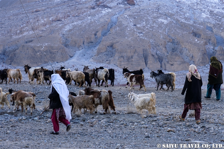
Inhabiting western India and central Asia, most markhor are found in the core zone of the mountainous region of Pakistan. At one point, poaching greatly reduced the population, but as of 2020, the population seems to be making a recovery thanks to efforts to control trophy hunting and reduce illegal hunting.


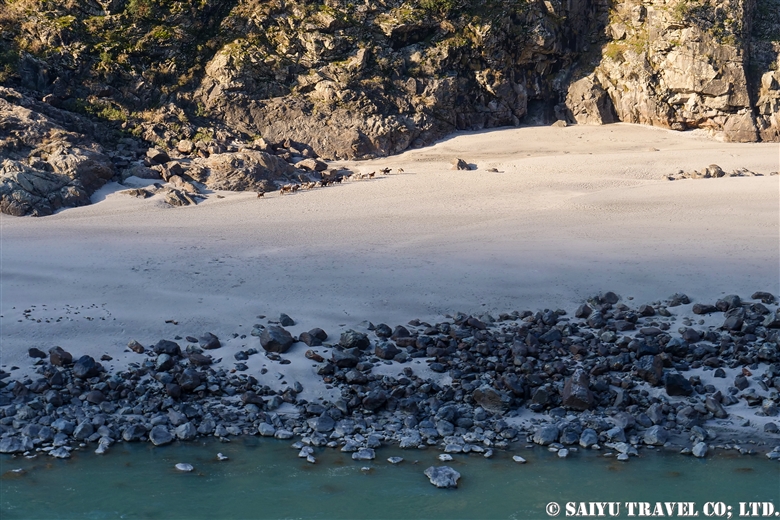
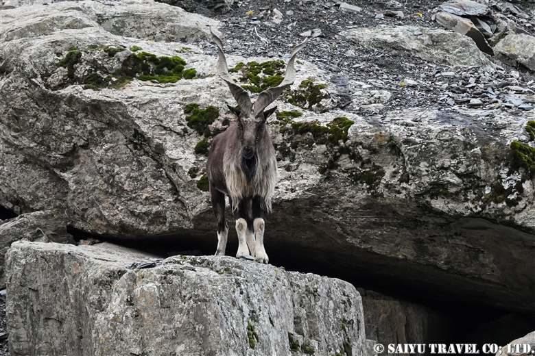
Visiting the Tooshi-Shasha Conservancy, we were lucky to get a good view of markhor just on the other side of the river.
The Tooshi-Shasha Conservancy, established in 1979 with 1,045 hectares, was expanded in 1998 to 20,000 hectares, as a community-managed reserve by the surrounding 7 villages. Unlike national parks where hunting is prohibited, it is a managed area where limited hunting is permitted.
In Pakistan, normally wild animals will flee at the sight of humans, due to having been hunted, but it was possible to view them quite closely in the Conservancy.


This is a male markhor. The ones seen in this area are a subspecies called “Kashmir Markhor.” In the northern part of Pakistan, there is another subspecies called the “Astor Markhor.”
The male here has a nice set of horns. In this season, they will come to lower elevations in search of mating opportunities with females.


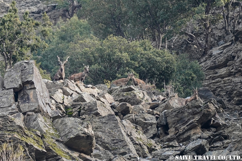
A herd of Kashmir markhor. Normally herds only have females and juvenile males but during this season, adult males can be seen with them.


Coming down the mountain.


He was getting very close. The male’s horns can reach up to 160 cm (63 inches). Females can also have horns, but they only grow to 25 cm (10 inches) in length. The females are also remarkably smaller in body size as well.


The male will raise his upper lip, sticking out his tongue…It seems this flehmen response is a reaction to the females in estrus.

The markhor’s breeding season is also sadly the same as hunting season for the rich trophy hunters. The hunting permits are auctioned to the highest bidders to wealthy hunters who aim to get these big-horned trophies for their collections.

In 2020, the year of an unprecedented pandemic, we had heard that the auctions went ahead and permits were already sold. But there was a big question if the hunters would show up or not! The day after we left, we heard that they did arrive from overseas to claim their permits. In the 20,000 hectare Tooshi-Shasha Conservancy there are an estimated 1,400 markhors (2015 population survey data) so every year 2 are allowed to be taken by the trophy hunters.

The Kashmir markhor are auctioned starting from 9,000 to 10,000 US$ and from there the permit is awarded to the highest bidder. Most of these proceeds (about 80%) are returned to the community, such as for schools and health care for the villagers. .

These 2 hunted markhor are therefore quite important sources of income for the locals and directly connects back to the conservation and management of these endangered wildlife. This is a model that modern Pakistan has which promotes the “Coexistence of Humans and Wildlife.”


Photo & text : Mariko SAWADA
Observation : Dec 2020, Tooshi-Shasha Conservancy, Chitral, Khyber Paktunkhwa
Special Thanks : KPK Wildlife Department, WWF Pakistan, Tomo AKIYAMA

Category : ◆Khyber Pakhtunkhwa > - Markhor > - Chitral > ◇ Wildlife of Pakistan
Tag : , , , , , , , , , , , , , ,

Petroglyphs of Shatial (Karakoram Highway)

Please visit our latest blog about Shatial Petroglyphs with more detail(2023)

Heading north on the Karakoram Highway as you enter Gilgit-Baltistan, the famous Buddhist archeological sites can be found between the Tangir and Darel Valleys. It is called the Shatial Rock Art Carving/Petroglyphs.

Since ancient times, this area was the point known as the “Old Silk Road” where the Indus River connects to the other valleys as a junction or crossroads.

Shatial has long been famous as a location for the “Ancient Buddhist Rock Carvings,” but even before these carvings were there, the tradition was for travelers, such as merchants and pilgrims, passing through Central Asia would carve their names and times into the rocks. These images of ancient characters (Sogdian or Bactrian) can be found near the bridges of Shatial.


People graze their goats along the banks of the Indus River. Rocks that were weathered down by water and time into sand. This is a place where people used to come to look for gold, but not so much anymore.


Taking the bridge that hangs over the Indus River in the Tangir Valley. Travelers from afar would cross this river during the winter months when the water was low, etching their footprints in the riverbanks. During the Buddhist era, monks and pilgrims would make their way to  “Gandhara.” They carved the Jataka tales and Stupas into the large rocks, creating an alter on the riverbanks.


The bridge of Shatial and Art Rock Carvings. Depicted is a stupa and the form of a Buddha carved into the stone.


Motifs of ibex are also engraved on the upper right. Ibex only live in elevations of 3,000m or higher so possibly the travelers saw them on the way along the Hunza River as they crossed the Hindu Kush – Karakoram Mountain range. There are no dates or names of the artists included with each carving, but these are precious relics that pay tribute to the history and people who have lived here since ancient times.


Sadly, the scenery along the Indus river is about to change.

There are two major projects to build dams between Besham and Chilas along the Karakoram Highway. There will be the Dasu Dam and Daimer Basha Dam Hydroelectric Power Plants installed along the river.
Although this plan has been in place for a long time, the construction is proceeding at a very fast pace as there is a shortage of power. This is following a decision to cancel the plans for a coal burning power plant.

Parts of the Karakoram Highway and some villages will be submerged, but along with that the historical features and the lifestyle of the people who live along the Indus river will also be forever altered. It is a great pity that such scenery along this great river will be lost.

Some of the main rock paintings will probably be relocated, but many of them will be submerged.

How much time does this scenery have left?

It was hard to get to and such a long-distance trip to get to see the Karakoram Highway and landscape. But it is in its final countdown.

Will this end up being only a precious memory?


Photo & Text : Mariko SAWADA
Visit: Dec 2020, The Karakorum Highway, Shatial, Gilgit-Baltistan

Category : ◆ Gilgit-Baltistan > - the Karakoram Highway > - Indus river bank > ◇ Rock carvings / Petroglyph
Tag : , , , , , , , , , , , , , , , , , , , ,

Red-billed Chough ( Upper Hunza)

In the mountainous areas of northern Pakistan, there are “red billed crows” and “yellow billed crows.”

Strictly speaking, they are classified into the crow family Corvidae and the genus Pyrrhocorax, appropriately called red-billed chough and the yellow-billed chough (also known as Alpine Cough).

‘Chough’ is pronounced “chuf /tʃʌf ” and they breed in the highlands above 5,000m during the summer season. In the winter, they form large flocks and decend down into the valley.

Distributed through the Eurasian and African continents, the genus is divided into eight subspecies. The one found in northern Pakistan is Pyrrhocprax pyrrhocorax himalayanus, which also inhabits the Himalayan mountain region to western China. A prominent feature are the large, bluish-purple glossy wings. In Europe and in Africa, Choughs can be observed at an altitude of 2,000 to 3,000 m, but in the Himalayan Karakorum, there is only a chance to see them at higher elevations of 3,000m to 5,000m.


I could see red-billed choughs along the riverbanks near Morkhun village. In the winter, the upper Hunza is strikingly beautiful, as a vast landscape of jagged rocks etched by time are layered with snow like a masterful piece of art.


While I was watching these red-billed choughs, a herd of goats and sheep passed through to go to their grazing pastures. In the Upper Hunza there are 7 villages that during the summer will keep the yaks, sheep and goats in the Khunjerab national park area. But in the tough winter, only the adult yaks are left in the highlands, while the yearling yaks born in the summer, goats and sheep are brought down to the villages at around 3,000m. Then everyday these herds are taken to the pastures to graze.


The paths that the villagers use to move the herds are lined with red & yellow billed chough. Generally since the red-billed will form large flocks, there are usually a smaller number of yellow-billed chough in the groups.


These are flocks of red-billed chough that are gathering seeds or fruit from the trees along the side of the Karakoram Highway.

Hippophae rhamnoides are a deciduous shrub found widely in Eurasia. In north Pakistan, it is a very important tree for wild birds, whose fruits are eaten during this harsh winter.


The long, curved, red colored beaks. But that isn’t the only thing that red! Their legs are also a red color!

Keep a watchful eye out when you are in the Upper Hunza and Skardu areas in the winter months. At first you may think you are seeing crows…but actually you might be lucky to see black birds adorned with red and yellow beaks! It is no ordinary crow!


Photo & text : Mariko SAWADA
Observation : Dec 2020, On the KKH ( Morkhun – Sost),  Gilgit-Baltistan
Special Thanks : TOMO Akiyama

Category : ◆ Gilgit-Baltistan > - Gojar > - Morkhun > ◇ Birds of Pakistan
Tag : , , , , , , , , , , , , , , , , , , ,

Pakistan International Airlines, take off from Skardu! The full picture of Nanga Parbat!

This is a description of my flight from Skardu to Islamabad using Pakistan International Airlines.

The Gilgit flight is usually very early in the morning, and due to the sunrise from behind the Nanga Parbat, everything looks white. However, the Skardu flight takes off a little later, when the sun is higher up in the sky. So it means the mountains are beautifully illuminated, although it may be a little cloudier when compared to the early morning hours.


When you take off from the Skardu Airport, you will see the outlying villages on the edges the city, poplar-lined streets, the Indus River, and boundary of the Katpana Desert.


The Skardu Fort, also known as Kharpocho, was built on a cliff along the Indus River in the 16th century.


Sand dunes in the Cold Desert can be seen stretching from the Skardu Valley to the Shigar Valley. It is a rare desert at a high altitude of about 2,500 m, which is quite unique in the world. The sand dunes are small and scattered from Ladakh, India’s Nubra Valley to Skardu but the dunes get bigger and more beautiful in the area from Skardu to Shigar.


This is Nanga Parbat, the 9th highest peak in the world. When I left Skardu, I thought it would be too cloudy and we wouldn’t be able to see it, but the southwestern side was clear.


The summit looked to be very windy, blowing the snow off the peak.


The main peak of Nanga Parbat is at an elevation of 8,126m, and the banks of the Indus River are at about 1,100m. So from the window of the plane, you can see the topography with a height difference of 7,000 m! It’s a really rare opportunity to be able to see 23 kilometers straight down and be able to compare the height of the mountains.


And this is the whole picture of the Nanga Parbat massif. The north side Chongra Peak, Raikot Peak, and the Main Peaks.


This is deep in the Naran Valley, Saiful Maluk Lake. It used to be such a pristine place, but regrettably, it has become a sad example of a tourist destination that has become full of garbage, due to the increase in visitors in recent years.

Well, we are coming back to reality now, and soon we’ll enter the Punjab Plain and touchdown at Islamabad.


Photo & Text : Mariko SAWADA
※These photos were taken on a September flight from Skardu to Islamabad on Pakistan International Airlines.

Category : ◆ Gilgit-Baltistan > - Skardu Valley > - Nanga Parbat / Himalaya Range
Tag : , , , , , , , , , , , , , ,

The Khyber Pass 2019

One of the places where it is very difficult to get an entry permit is the Khyber Pass. It is right on the border with Afghanistan, located in the former tribal area on the road leading to Torkham. In 2018, it was transferred to Khyber Pakhtunkhwa province, but it is still one of the more difficult places to visit.

The historic Khyber Pass has been an important trade route connecting the eastern and western cultures. The Sulaiman mountains on the border are where Alexander the Great’s army, and the Chinese Buddhist Scholar, Xuanzang (In Japanese known as Genjō) crossed here. During the Mughal Dynasty, it was developed as the Grand Trunk Road running from India to Kabul in Afghanistan. It also became a significant battlefield from the First British War to the independence of Pakistan in modern times. After Pakistan’s independence it became a tribal area.

For travelers, it is an exciting part of history and romance as a pass that connects the “Central Asian world” and the “Indian world”.


The first monument from Peshawar to Khyber Pass is this Khyber Gate ‘Bab-e- Khyber’. Peshawar was already quite a busy town, but the tram in the middle of the main road made the road even narrower and the traffic was horrible.


The giant Shagai Fort was built by the British Army in 1920 and is now used by the Pakistani Army.


Students who we passed along the road. These students commuting to school was really refreshing in the old tribal area.


This was the narrowest place of the Khyber Pass road, mountains on both sides, and for that it became a strategically important position. It a fierce battlefield during many wars. This is the Ali Masjid Mosque and on the hill is the Pakistani military fortress Ali Masjid Fort.


One of the most shocking things we learned was that the fortress was built beside buddhist stupa of Kushan Empire, which amazingly dates back to the 2nd and 5th centuries.
This is Sphola Stupa sits on a three-story platform. It housed some Gandhara sculptures, Buddha statues that were excavated in the early 20th century.


The other shocking thing is the miserable state of this “Khyber Railway” track. It is such a pity because I expected that the “Khyber Railway” steam locomotive would be revived to invigorate the domestic tourism.

The railroad was originally opened in 1926, while under British rule for the purpose of transporting military supplies. The trip from Peshawar to Landi Kotal, which is 34 kilometers long and rises in elevation by 600 meters, crosses 34 tunnels and 92 iron bridges, and the steam locomotive trip here was one of the highlights of tourism.


It is said that the military from various times and various countries that passed through this area have carved their coat of arms on the rock surface as a memorial.


Then we passed through the Landi Kotal market. This was once a famous place for the smuggling trade.


This is the Michni Checkpost where “The Guardians of Khyber Pass” overlook the Pakistani border with Afghanistan. The observatory serves as a lookout post over at Afghanistan.


A view of Afghanistan from the Michni Checkpost. In the valley, there are immigration and customs offices of both countries, and passing through here, will take you to Torkham.

Click here for more information on Khyber Pass (It was written based on photos from around 2008. Please compare it with the old photo and see how it has changed.)


Photo & text : Mariko SAWADA
※These photos were taken in October 2019 during the visit.

Category : - Peshawar / Khyber Pass > ◆Khyber Pakhtunkhwa
Tag : , , , , , , , , , , , , , , , , ,

Bazaar of Landi Kotal

Landi Kotal is a small town, found on the way from Peshawar to the Afghanistan border town of Torkham.  Located in the former Federally Administered Tribal Areas (FATA), it was once known as the “Smuggling Market,” known for trading goods like appliances and car parts into smuggled items like weapons and narcotics. When I first visited around 1992, I was surprised to see chocolate-shaped narcotics lined up in stores.
Now the status of the “Smuggling Bazaar” has disappeared and it is a normal market for rural Pashtun tribes.


The shop owners call out ‘Hello! Hello!’ to try to earn some business.


When a foreigner pass them by, everyone pays attention! It really reminded me of old Pakistan.


The Pashtun officer who accompanies us, took us to a local butcher shop and request some popular Landi Kotal Domba Sheep. These unique sheep have a big butt which is a delicacy for the locals.


We purchased a cut of meat and it was grilled over charcoal.


This is a typical Domba sheep lunch. We ate it along with a the local green tea called Kahwa Tea!
By the day, I did not see any women, the whole day.


Photo & Text : Mariko SAWADA

Visit : Oct 2019, Landi Kotal, Khyber-Pakhtunkhwa

Category : - Peshawar / Khyber Pass > ◆Khyber Pakhtunkhwa
Tag : , , , , , , , , , , , , , , ,

Lahore’s Old City Walk

Lahore Walled City Bazaar


Our friends from Switzerland and Mexico went for a stroll through the Old City of Lahore.

The Old City of Lahore, also known as the “Walled City of Lahore,” was established about 1000 years ago as a fortified town surrounded by mudbrick walls and gates. During the Mughal Empire, it prospered as the capital city.

Currently, only a part of the city walls remains. However, since 2012, developments have transformed the Old City into a tourist destination, with the cooperation of the Norwegian and US governments. From the Delhi Gate to the Wazir Khan Mosque, tourists can now enjoy the exciting “Old City Walk”!


Video & text: Mariko SAWADA

Visit: Mar 2020, Lahore, Punjab

Category : = Video Clip Punjab > - Monument / Heritage of Punjab > ◆ Video Breathtaking Views of Pakistan > ◆ Punjab > - Lahore
Tag : , , , , , , , , , , , , , , , ,

Best Views of Nanga Parbat! PIA Pakistan International Airlines ★ Skardu Flight

A panoramic view of the Nanga Parbat massif from a flight from Islamabad to Skardu

These mountain flights in northern Pakistan are often canceled. The reason is, of course, the quickly changing weather in the mountains. Considering that, in the last few years, the flight rate has improved considerably. In particular, if you were to try to move by car the distance of the Skardu flight, it would take two full days by land. But taking this “picturesque flight” it only takes one hour to travel the same distance.

You should really see this scenery from the Skardu flight! For the Skardu line, if taking the regular route (depending on the weather), you will see Nanga Parbat on the right and K2 on the left (if you are lucky!) just before arriving in Skardu. K2 is often hidden by the clouds and is only visible a little at the very end of the flight. So sitting on the Nanga Parbat side will give you more time to enjoy the mountainous view.

When you take off from Islamabad, you will increase altitude while slowly circling up in the Punjab Plain. Soon, you start to see the mountainous view at the western end of the Himalayas. If you look closely below, you can also see the Indus River and the Karakoram Highway running alongside it.


Nanga Parbat is seen as a gigantic mass of mountain. It is 8,126m, the 9th highest peak in the world.


My personal favorite is to see both the Indus River and Nanga Parbat. It’s hard to see in the photo, but below you can see the Indus River and the Karakoram Highway. The Indus River is a large river that crosses the border from Ladakh, India, and enters Pakistan passing through Skardu, and flows beyond that into the Arabian Sea.

This great mountainous region of Pakistan borders the Indus River. The Himalayas to the south of the great river and the Karakorum Mountains to the north of it. This is where the ancient Indian Plate and the Eurasian Plate collided to form these vast mountain ranges.


And in this photo, at the bottom, the altitude of the riverbank of the Indus River is 1,100-1,200m, while at the top, the summit of Nanga Parbat is 8,126m. If you draw a straight line, there is a height difference of 7,000m in a distance of about 23km!


Shortly after the view of Nanga Parbat disappears, you enter the Skardu Valley. Surrounded by the mountains of Karakorum, the open valley of Skardu contrasts so much. It is a magnificent view shaped by the Indus River.


Pakistan International Airlines circles around the town of Skardu, which is like an oasis lined with poplar trees. You will see Satpara Lake and finally land at the airport in Skardu.


Arrived safely in Skardu.

Can you see the mountains if you can’t get the window side? ···Nope!  There is no choice but to take turns looking out the small airplane windows. And…should your flight be cancelled, you have to stay flexible and just be content to enjoy the views of the Karakoram Highway and the mighty Indus River from the car!


Photo & text: Mariko SAWADA

*The photo is taken from the right seat of the actual Pakistan Airlines Skardu flight.

Category : ◆ Gilgit-Baltistan > - Skardu Valley > ◇ Mountain of Pakistan > - Nanga Parbat / Himalaya Range
Tag : , , , , , , , , , , , , , , ,

(video) Lahore Fort – History by Night

History by Night at Lahore Fort on the weekend evening.

Although held in Urdu for the general public in Pakistan, this is the only way to enter the illuminated treasure of Lahore Fort, Sheesh Mahal.


Video & text : Mariko SAWADA

Visit : Mar 2019, Lahore, Punjab

Category : = Video Clip Punjab > ◆ Video Breathtaking Views of Pakistan > ◆ Punjab > - Lahore > ◇ Heritage of Pakistan
Tag : , , , , , , , , , , , , ,

The Truckers of the Indus Highway: It’s Harvest Season!

November, Sindh Province when wheat and millet harvest season begins. We regularly saw these trucks, filled beyond capacity with wheat, along the National Highway (N5) and the Indus Highway (N55).
As you head south on the Indus Highway, there were many trucks carrying their harvest from the Dadu Region.


According to the truck driver, the packed material was not the actual wheat but the straw leftover after the wheat was harvested. Each truck can carry about 8,000 kilograms (8 tons) from Dadu down to Karachi’s livestock feed factory. Selling one truckload can pay about 2.5 million rupees (~$15,000 USD ).


The long line of trucks that wait at the check post.


While waiting in line, some of the truck drivers graciously allowed our Japanese tourists to take a commemorative photo from inside the truck. These eye-catching trucks are not only nice on the outside, but the colorful interior is also elaborately decorated as well.


Photo & text: Mariko SAWADA
Visit: Nov 2019, Indus Highway, Dadu, Sindh


Category : - National & Indus Highway > ◆ Sindh
Tag : , , , , , , , , , , , , , , , ,