Taxila – Mohra Moradu

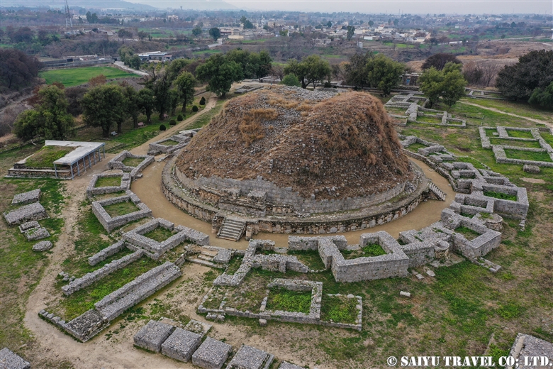
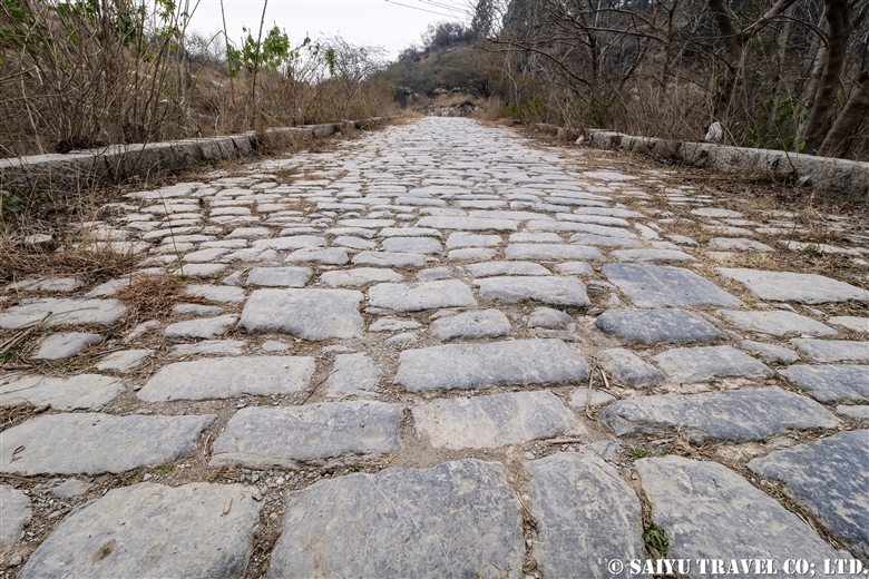
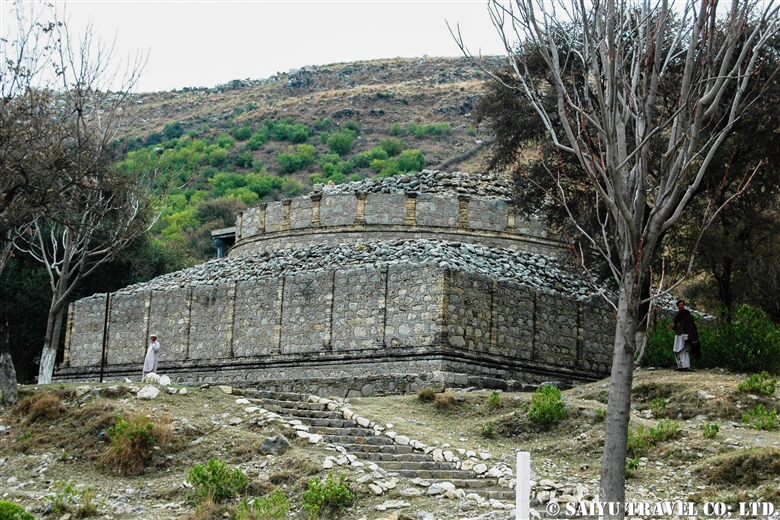
This is Mohra Muradu, one of Taxila’s historic Buddhist ruins. It’s actually a mysterious sounding name, but the ruins of Gandhara’s monastery and stupa is simply taken from the nearby village, Mohra Muradu.
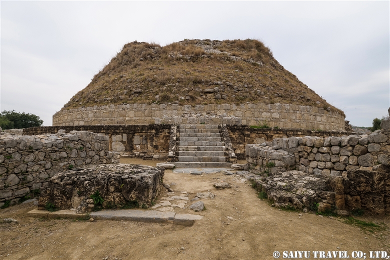
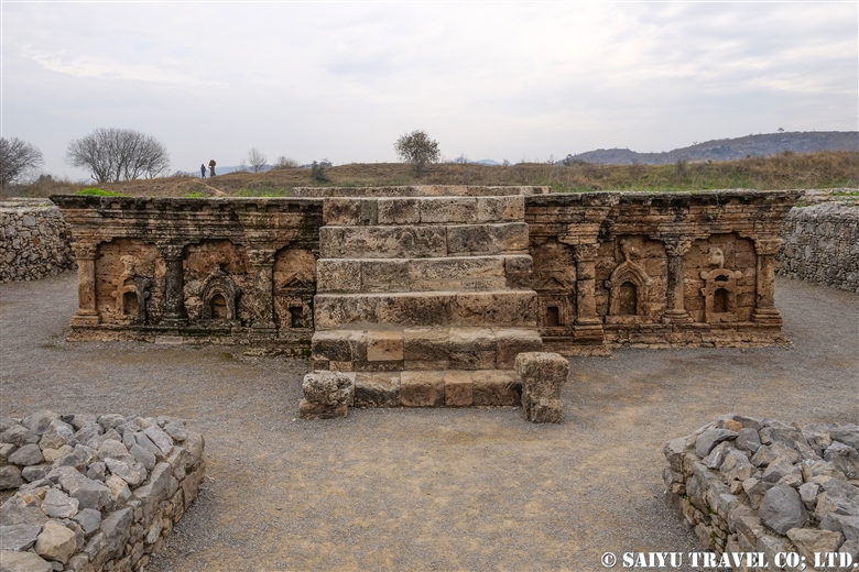
This picture shows the main stupa square platform, which is 4.75m (15.6 ft) tall.


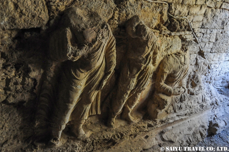
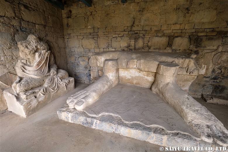
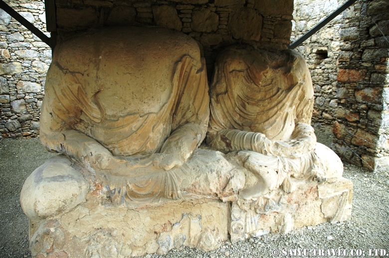
Mohra Muradu has two stupas. There is a main stupa and a smaller stupa to the south of it, and there are stucco statues (decorative stucco) of Buddha and elephants which remain preserved on the walls.


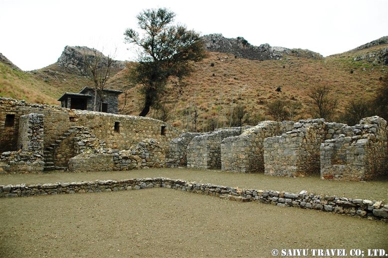
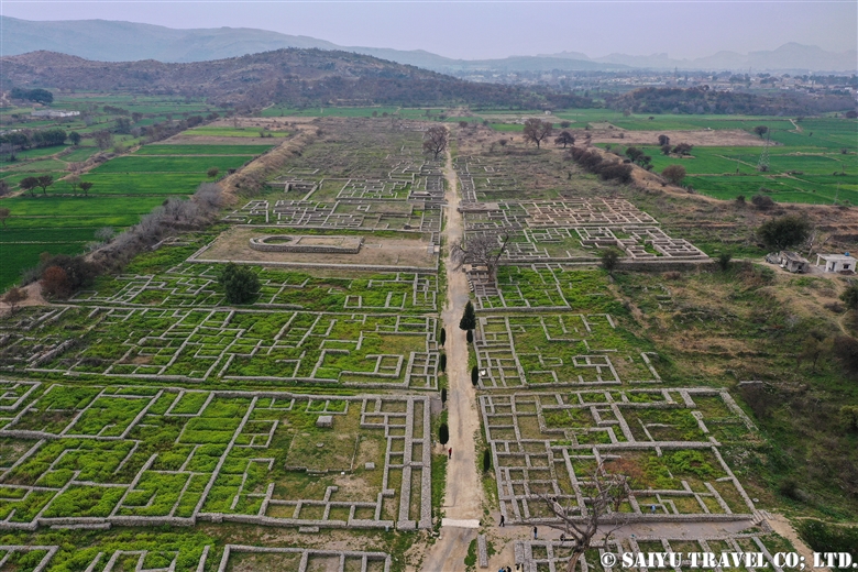
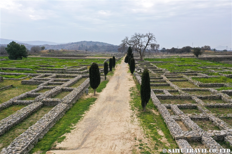
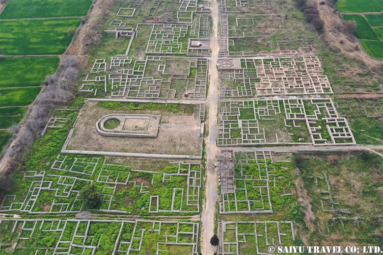
The monastery has 27 cells on all four sides of a square courtyard, and some of them have stairs, so you can see some had additional levels. The central part of the garden is empty, possibly used for ceremonial baths.


This is a preserved Stucco Buddha statue (decoratively lacquered) in the monastery. The coloring remains despite the many years that have passed.


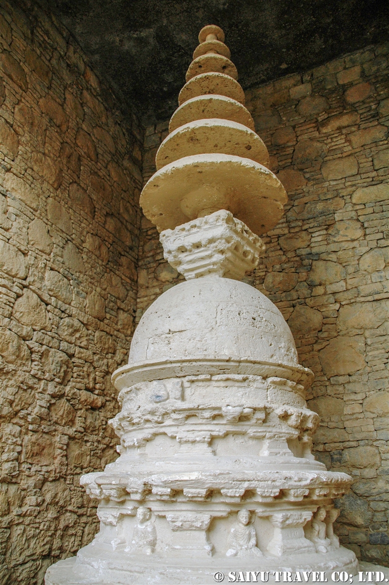
The highlight and masterpiece of Mohra Muradu is this 4m (13 ft) tall monumental votive stupa. Found in a small cell of the monastery, it is a hemispherical bowl on a circular platform, with a flat box-shaped fixture on it (probably a place to store a sarira, a container holding the Buddha’s remains). And on top, is a decorative 7-layered umbrella-shaped structure.
When you have so many layers, it doesn’t even really look like an umbrella, but it was a must-have item during the Buddha’s day. When a king or nobleman was outside, servants held an umbrella over by his head. It became a symbol of respect as well for Buddha, and the believers donated umbrella covers stacked to the top.


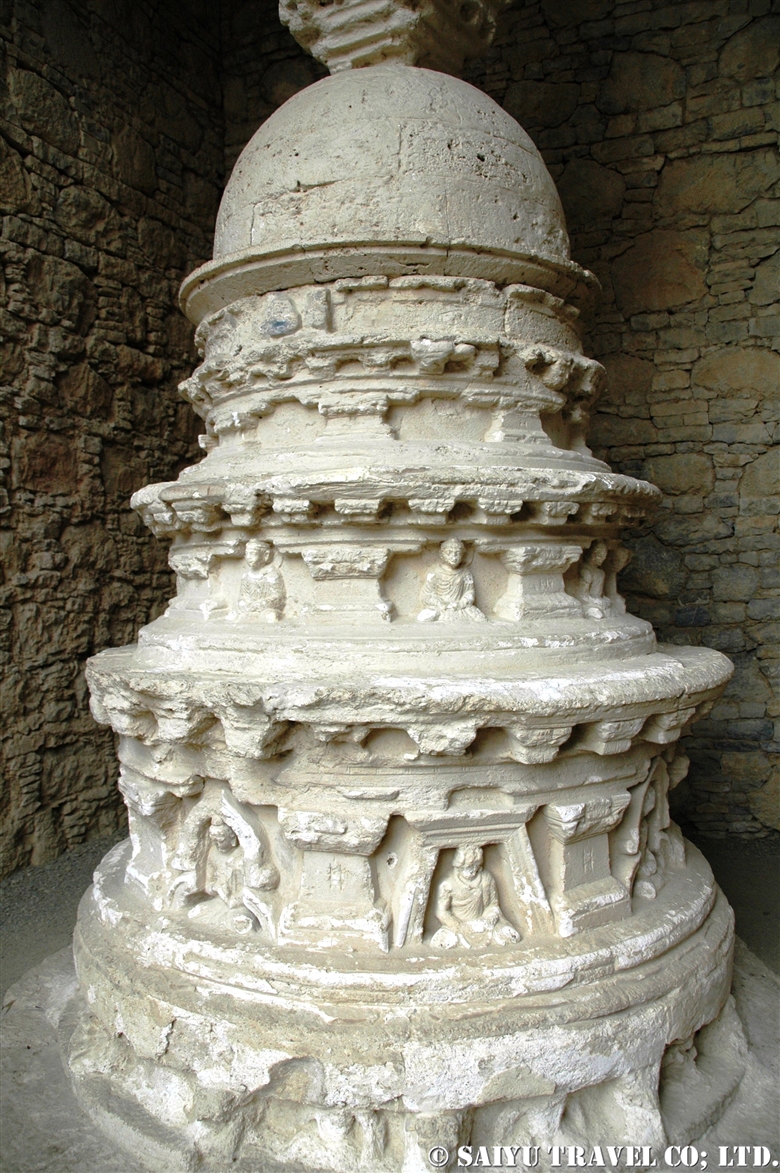
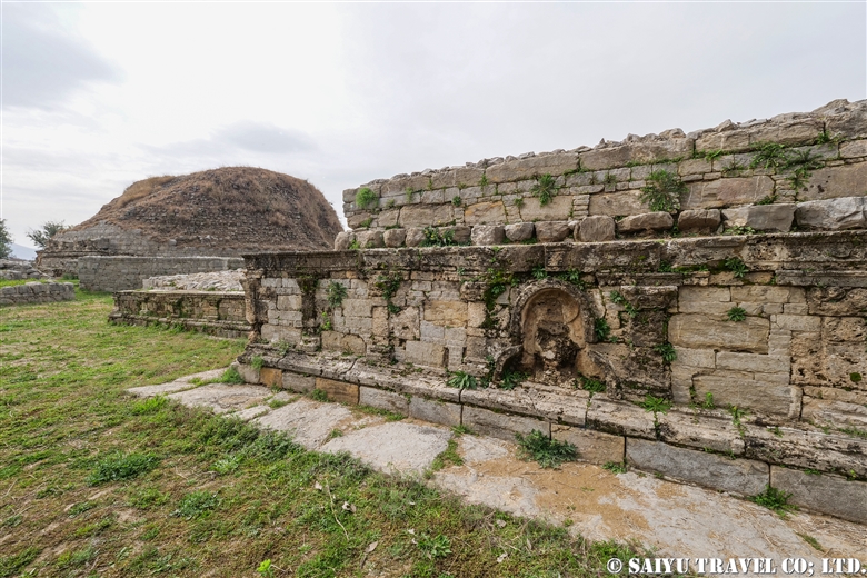
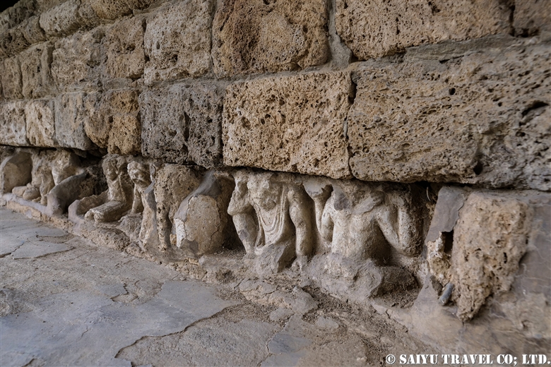
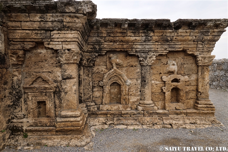
This is the 5 layer circular platform of the votive stupa. Each panel on the sides is separated by Corinthian columns (influenced by the Greeks) and decorated with carved reliefs of Buddha.
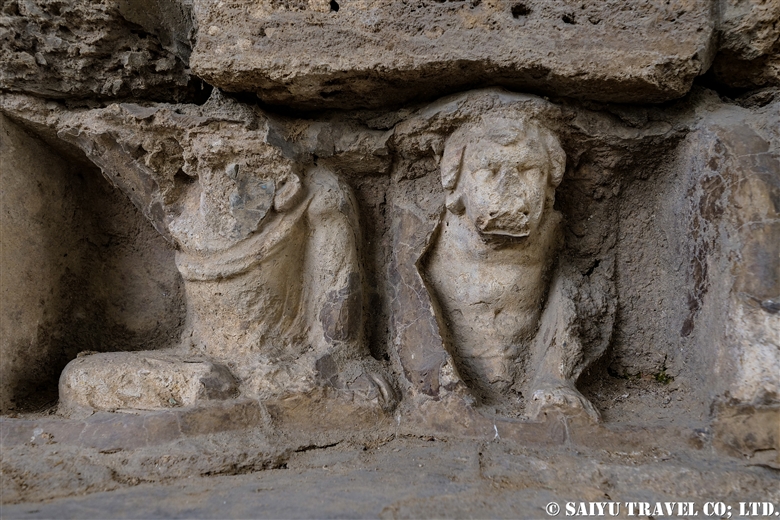
Also supporting at the base, is the elephant and the Greek god Atlas, who was said to “carry the sky at the west end of the world.”


Photo & text : Mariko SAWADA

(Photos are from a trip in 2005)

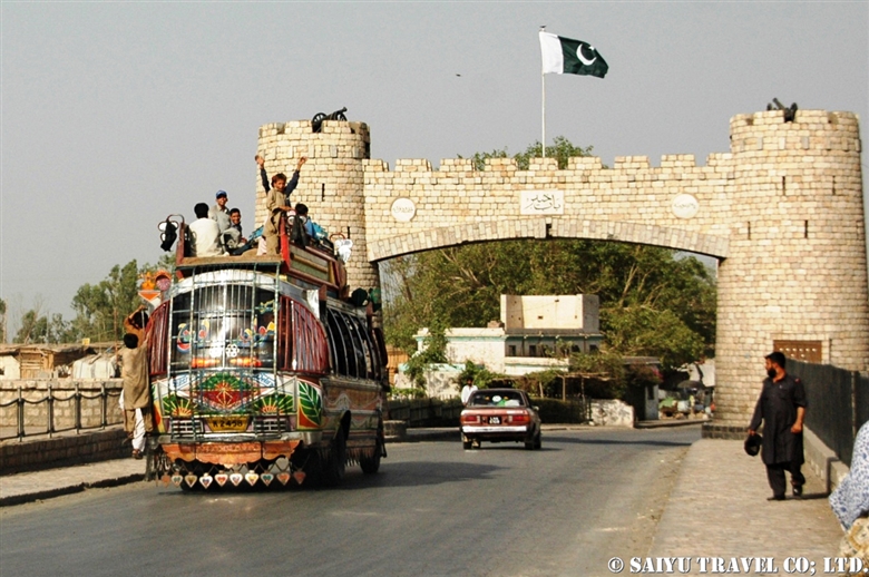
Location : Mohra Moradu, Taxila, Punjab

Category : - Monument / Heritage of Punjab > - Taxila > - Gandhara > ◆ Punjab > ◇ Heritage of Pakistan
Tag : , , , , , , , , , , , , , ,

Dharmarajika – Taxila

In the 3rd Century BC, there were 2 stupas built by the Mauryan Empire King Ashoka in the Ghandara region. One is the stupa at Butkara ruins in Swat, and the other is the Dharmarajika stupa in Taxila.

Today, the oldest stupa which overall retains its original shape is the one in Sanchi, India, but there are similar huge stupas in the Ghandara region, built in the same circular form. However, unlike Sanchi’s stupas, they do not have column shields or trana. Instead there are shrines and smaller stupas around the main stupa.


The main stupa stands at height of 15m and a diameter of 30m.
Around 500 BC, the Buddha entered Nirvana (passed away) around Kushinagar. Seven days later, he was cremated and the relics (sarira) were placed in a relic urn in eight tombs at the bottom of the center of the tomb. This was the first stupa, and the sarira and its urn were worshipped.
In 3rd century BC, the Mauryan King Ashoka collected the relics (sarira) and distributed them to place in newly built stupas. The Dharmarajika stupa enshrines the relics.


The Main Stupa has a path of circumambulation (a path around the temple for walking prayer) and around it, there is a group of shrines and smaller stupas that were built in the 1st century BC to 4th century AD by the Kushan Empire in Ghandara.

On the walls of the square-shaped platform, you can see the Ghandara style architecture with panels and wall tiles separated by the Corinthian columns.


Decorations on the base of small stupas show elephants and figures supporting the platform. These are the figure of the Greek God Atlas.


Atlas is a Greek myth that supports the sky at the western end of the world. In Gandhara, it appears to support the pedestal of the Buddha and the platform of the stupa. The Greek gods seem to be supporting the Buddhist world view, the beautiful expression of the fusion of Eastern and Western cultures … it’s truly romantic.


There are remnants of stucco Buddha status inside the shrine, but unfortunately, they were destroyed. The Stucco statue is a clay statue made in Ghandara that was popular from the 3rd to 4th century AD.

For sightseeing in Taxila, the three main attractions are the Taxila museum, city ruins of Sirkap and the Jaulian monastery, but I hope you can take time to visit the Dharmarajika, too!

Text & Photo : Mariko SAWADA
Visit : Feb 2020, Dharmarajika, Taxila, Punjab


Category : - Monument / Heritage of Punjab > - Taxila > - Gandhara > ◆ Punjab > ◇ Heritage of Pakistan
Tag : , , , , , , , , , , , , , , ,

Sirkap – Taxila

About 30km northwest of Islamabad, the Taxila ruins are located at the eastern edge of an area that once flourished in Ghandara art (Buddhist visual art). Taxila is a group of archeological sites, stupas, monasteries etc. but among them, Sirkap city archeological site is an important area which is a must-visit for all tourists.


In the 2nd century BC, the city was built by Bactrian Greeks (Indo-Greek) who flourished in northern Afghanistan. The ruins of the town are located off of the main street and they spread out in a grid pattern, the foundations of the shops, Buddhist temples and Buddhist pagodas endure.


Ghandara stood in a cultural intersection where it received the cultural influence of India from the east and the cultural inspirations from Greece and Persia (Iran) from the west. The iconic buildings that symbolize that remains in Sirkap.

This is the “Double-Headed Eagle Stupa” that remains in Sirkap. There are three panels separated by Corinthian wall columns with shoots of Acanthus decorations on the wall of either side of the stairs in front of the square platform.


The beautifully preserved panels just to the right of the stairs.

In the panel on the very left, the Greek temple style building with the triangular gables.
Decorating the central panel is a double-headed eagle-like bird perched on top of an arched building shaped like the entrance to the Indian Chaitya Temple. The double-headed eagle is a design often found in Western Asia such as in Hittite and Babylonia.
On the rightmost panel is an Indian Torana (like the Indian Sanchi stupas) with a bird-like figure on top of it.

The Taxila Double-Headed Eagle Stupa is a structure that captures your imagination, blending the architectural artistry of India, Greece and Western Asia.


An aerial view of Sirkap, taken by drone, shows a large circular building foundation on the left side of the main street. It is said that it is the remains of a Chaitya temple because it has the same structure of the sacred temples.

It had been quite a long time since I was last able to visit Sirkap, but this time, I could see many students from Pakistan and families coming out for a picnic. Most of the Ghandara ruins are located on mountain tops, but this one is a flat, easy to access spot where people can enjoy the family time.


Photo & Text : Mariko SAWADA

Visit : Feb 2020, Sirkap, taxila, Punjab

Category : - Taxila > - Gandhara > ◆ Punjab > ◇ Heritage of Pakistan
Tag : , , , , , , , , , , , , , , ,

(Vlog) Safe? Discovering the heart of Pakistan!Is it Safe? Discovering the heart of Pakistan! (including an insightful Travel Vlog shared by our customer)

This February, we traveled the heart of Pakistan with a Swiss and Mexican couple, Lucas and Patricia. Indus Caravan lead the trip from Lahore to Peshawar along the Grand Trunk Road, the railway made during the British-Indian Empire. Please check out the travel vlog from the eyes of a tourist traveling Pakistan, with the narration in Spanish and the subtitles in English.

Safe? Discovering the heart of Pakistan!

The insightful video takes you along the journey from Peshawar to Rhori, a riverside town to the Indus and the train station. The vlog touches on the “History and Hospitality of Pakistan” from the Mughal period, the influence of the British-Indian Empire, to now.


Text : Mariko SAWADA

Special Thanks to SUMMERMATTER DIAZ ENRIQUETA PATRICIA.
Please visit her website : https://elpadiro.ch/

Category : = Video Clip KPK > = Video Clip Punjab > ◆ Video Breathtaking Views of Pakistan > ◆Khyber Pakhtunkhwa > ◆ Punjab > ◇ Pakistan Railways > ◇ Pakistan Travel Tip
Tag : , , , , , , , , , , ,

”Kuch”, a summer in Shimshal Pamir

In northern Pakistan, near the border with China, we spent time with the women of Shimshal village as they take their livestock to the ‘Pamir’ in a migration called “Kuch”. This is about our Kuch experience, which took place in June 20, 2011.

In 2010, due to the traffic restrictions around Attabad Lake on the Karakoram Highway, I was unable to participate in the Kuch. In 2011, our   “Shimshal Pamir” tour became a kind of event with participants who wait for a year. For the Shimshal Village, it ended up being the biggest ever ‘Yak Safari’ group since they started tours to the most difficult Shopodin Pass at 5,346m. It was made up of 52 yaks and 61 people, making it the “Big Kuch” including our group.
These photos show the state of Kuch in 2011. The number of women joining Kuch has drastically reduced in 2018 and 2019, making this tradition a thing of the past, unfortunately.


On the morning of Kuch, we left the camp where shimshal’s women  had been staying at from May 20 to June 20. As we shut the door behind us, we said goodbye to our life in the summer village of Shuizherav (or Shuizerav). The elderly women, give us all a traditional send-off, with their cupped hands turned up, as a sign of respect.


The corral of the sheep and goats was opened, and the large group climbed up to the first pass. The local woman, walks while holding the fragile things like a lantern and even a newborn goat that is still unable to walk.


They made time for us to take a commemorative photo together just up the Shuizherav Hill. The Kuch tradition can only be carried out with the close cooperation of the whole family and good friends of their fellow villagers.


Shimshal women carrying children and goat kids in their arms. The goats and sheep walk slower, so the women take care of them as a separate group.


Our group was riding along on the yak, together with the female yaks and the group of calves. During the Kuch, the Yaks are being pushed along from behind, so they tend to walk a little faster paced then normal. I was simply blown away by the powerful women of Shimshal, as they power walked at such high elevations of around 4,500m.


As I looked behind me, the herd was coming up from behind us. From the Shimshal Pass (4,735m) with female yaks and calves group along with the villagers, we aim toward our destination of Shuwerth. I was so overcome by excitement, that I forgot about the high altitude.


The Shuwerth summer village (4,670m) is where the women will live from June 20 for three months. Called the ‘Pamir’ by the Shimshal villagers, it is a rich field where humans and livestock live close together. I was invited to take part in the ceremony to give thanks to their God for our safe arrival in the ‘Pamir’, and then ate some Shimshal cheese together with the everyone.
So many goats, sheep and yaks…too many for me to count. In the midst of the baa-baas (crying sounds of the goats and sheep) and the moo-moos (crying sounds of the yak calves), there is a shared sense of presence as we are making our way together towards ‘Pamir’. It will be my treasured memory forever.


Photo & text: Mariko SAWADA
Visit: Jun 2011, Shimshal Pamir, Shimshal, Gilgit-Baltistan

※This article is updated and based on the blog “Salaam Pakistan” which was first uploaded in July 2011. The Shimshal kuch tradition is rapidly waning. I have heard that you can no longer see many women from the villages in 2018 & 2019.


Category : ◆ Gilgit-Baltistan > - Shimshal
Tag : , , , , , , , , , , , , , , ,

Shimshal Pamir : Getting Over the Shopodin Pass(5,346m)with 52 Yaks and 61 People

This entry is about the the Shimshal Pamir journey in June 2011. In this trip, I was focused on the ‘yak route’. In 1993, the ‘Tang route’ was created because the Yaks could not pass there.  This ‘yak route’ allowed the Shimshal people to connect to the meadows, passes and villages together during their seasonal passage. One of the most daunting, as well as a highlight of the route, is going over the Shopodin Pass (5346m/ 17,540ft).

This time, as a record in the history of Shimshal, 52 yaks, and 61 people (11 Japanese, 3 Saiyu Travel staff of Pakistan [Pakistanis] and 47 Shimshal villagers) challenged the pass.


Climbing the Shopodin Pass. At the end of June, after over 5,000m elevation, there were pockets of remaining snow, and the melting snow water created muddy waterfalls. I climbed over a 150m of rocky terrain and from there on, rode on a yak directly to the top of the pass.


Nearing the top of the pass soon. This is Mr. Qazi, who is known as the Shimshal village ‘Yak Master’. In his youth, he had climbed high peak in the past, but today, he rode his own yak over the pass.


Just before reaching the top of pass, we offered our prayers of gratitude.


At the top of Shopodin Pass. Blessed with good weather, the view of the pass where we reached with the yak and the villagers was utterly breathtaking. From the cliff edge of Shopodin Pass at 5,346m, the even taller ranges of the Upper Hunza Passu’s Sispare and beyond to the Hisper Mustagh mountain range’s Distaghil Sar, Adver Sar, etc. a panorama of 7,000m peaks, an amazing landscape spreads out before us.

Later, there was a celebratory dance on the top of Shopodin Pass. When you are happy, you dance…that is the culture of the Pakistanis in the city as also, for the Pakistanis in the mountains. In this Shimshal mountain trip, I heard many times, the songs by the elders, ‘Pamir means a rich pasture where humans and livestock living together’. I was deeply touched by this song which celebrates living with nature and giving thanks to the beauty of it.


So the difficult thing about the Shopodin Pass, is not uphill but the downhill climb. The dry 35-degree inclination downwards opposite the snow slope is the hardest section of the pass. Some paths are muddy with the snow water, and some are slippery rocky ledges.


It took about 2 intense hours of downhill paths, until we could reach the destination of the Zargarben – Shopodin camp site. Of course, the yaks could make their way down quickly and were already there eating grass when we arrived.


The next day, we arrived at Shimshal village. It would be the last day where I would walk together with the yaks and villagers. There was only a few more hours to be together with the team, that had challenged the journey for the last 12 days.

I offer my deep gratitude to the Shimshal villagers, the yaks and their handlers, the mountain guides, porters and everyone who participated in this tour.


Photo & text: Mariko SAWADA
Visit: Jun 2011, Shopodin Pass, Shimshal, Gilgit-Baltistan

※This article is an updated version of the blog posted in ‘Salam Pakistan’ in July 2011.

Category : ◆ Gilgit-Baltistan > ◇ Mountain of Pakistan > - Shimshal
Tag : , , , , , , , , , , , , , , , , , ,

(Vlog) Adventures Exploring the Impressive Mud Volcanoes in Balochistan (including an insightful Travel Vlog shared by our customer) 

In February of this year, we visited Balochistan with a Swiss-Mexican couple, Lucas and Patricia, and photographer Toshiki Nakanishi. Patricia made a wonderful travel Vlog of our travels. Narrated in Spanish with English subtitles, please see her video, as seen by the tourist.

Patricia is a wildlife photographer. Before coming to Pakistan, she was asked many times by her Swiss friends, “Pakistan? What wildlife is there to shoot? But isn’t it dangerous?” And now, after having been there to see for herself, she made this video “to show everyone the beauty of Pakistan and our journey there!”

And now, due to the Covid19 Pandemic, in the era of #stayhome…Patrica said “Now, I have lots of time!” Patricia, thank you for opening a way for the future of tourism in Pakistan!


Text : Mariko SAWADA

Special Thanks to SUMMERMATTER DIAZ ENRIQUETA PATRICIA. Please visit her web site: https://elpadiro.ch/

Category : = Video clip Balochistan > ◆ Video Breathtaking Views of Pakistan > ◆ Balochistan > ◇ Pakistan Travel Tip
Tag : , , , , , , , , , , , , , , ,

”The King’s Road” Traveling to the end of Grand Trunk Road

When driving from the capital city of Islamabad to Peshawar, you might be asked “Will you take the motorway? Or the GT Road?”

This GT Road refers to the “Grand Trunk Road” the main road of the ancient Mughal Empire or “The King’s Road” Of course, it looks just like any other modern asphalt road, but it has a deep history.

In the first place, “The King’s Road” = Grand Trunk Road is an extensive network created by the Afghan dynasty Sher Shah Suri who, in the 16th Century, took power after the Mughal Empire and set about improving the roads. During the brief reign of the Suri Empire, the road from Agra to his hometown Bihar (India) was first completed. Then eastward to what is now Bangladesh, the road to Sonargaon was made. And westward to Multan, which is now Pakistan. The Mughal Empire returned and the whole Empire was expanded from the current port of Chittagong (or Chattogram), Bangladesh to the east, across the Khyber Pass to Kabul, Afghanistan, and developed into a vast Mughal Empire.

This “King’s Road” was rebuilt during the British India era. The British launched three invasion towards Afghanistan but failed to colonize it. This section from Calcutta to Peshwar, ending just before Afghanistan, was given the name “Grand Trunk Road” and it remains so to this day.
There are still remnants of the glory days of the prospering “Grand Trunk Road” that have been retained in small pockets.

Mughal Era Cobblestone Road

On the outskirts of Islamabad, there remains a cobblestone road from the Mughal Empire’s Grand Trunk Road. It can be found just beside the more modern GT Roads. The cobblestone road has the traces of wear by carriage wheels that travelled over it for so many years.

Lahore Fort (a UNESCO World Heritage Site)

The ancient capital of the Mughal Empire, Lahore. Since then, many buildings have been built on top of the original castle that remains since the Mughal era. This is a photo of the main gate at night, Alamgiri Gate. The Shah Jahan period was when the gorgeous additions were made with the famous Sheesh Mahal “Palace of Mirrors” reminiscent of the prosperous times of the Mughal Empire.

Rohtas Fort (a UNESCO World Heritage Site)

Built by Sher Shah Suri, sitting above the Grand Trunk Road. The Rohtas Fort was built by Sher Shah Suri to protect the strategic road from Peshawar to Lahore.

Caravan Serai

In the old bazaar of Peshawar, remains the caravan serai  which was a place for travelers to rest from their long journey. It was during the old days, that many merchants traveled through here and supported the vast Mughal Empire, and afterwards in colonial times as well. The Peshawar would have been a thriving place with products from all over Central Asia and India.

Khyber Gate

When traveling from Peshawar to Khyber Pass this is the monument and gate that stands at the entrance. On one side of the road is Jamrud Fort, a fort built by Sikhs who invaded an old fort and rebuilt it in 1823. In front of Khyber Pass, which connects between Central and South Asia, you can see the history of the battles that took place between various ethnic groups. After you cross the Khyber Pass, the Torkham boarder and the Grand Trunk Road continues into Afghanistan to the west.

Babur’s Tomb

The first Emperor of the Mughal Empire was Babur. Originally from Central Asia, he set up his first base of operations in Kabul, and from there, set up the Punjab Plain, and conquered India, then in 1526 he founded the Mughal Empire as the emperor, in Agra. Just 4 years later, he died in Agra. He wished to have his tomb in his beloved Kabul, so after a war and some years later his family built a tomb in Kabul. (This photo was taken during restorations of Babur Gardens, so now it is even more beautiful to visit and see the elaborate Mughal Empire’s tomb.)

After the war in Afghanistan, the tomb of Barbur was in horrible disrepair, reflective of the destruction of the great Mughal Empire’s war history. The Afghanistan’s Urban Heritage Project to develop the city and revive its cultural identity with Bagh-e Babur, Babur’s Garden. It overlooks the same city that started and ended the Grand Trunk Road.

Winter in Kabul, from the Babur Gardens with the tomb of Babur.


Photo & text: Mariko SAWADA

※Photos of Kabul are from 2006 and the scenery may have changed since then.
※This article is an updated version of the blog posted in “Salaam Pakistan” in June 2011.


Category : - Monument / Heritage of Punjab > - Grand Trunk Road > ◆Khyber Pakhtunkhwa > ◆ Punjab > - Lahore > ◇ Heritage of Pakistan
Tag : , , , , , , , , , , , , , , , , , ,

Shimshal Pamir: Will you try the Kuch? I did!

Shimshal Pamir’s summer KUCH, a Summer migration
If you know anything about summer in Shimshal, then you know there is a big part of life the “Pamir.” This is the tradition of  KUCH, where the villagers move their livestock from Shimshal Village at the end of May. They first go to the summer village of Shuizherav and then at the end of June, make their way to the second summer village of Shuwerth.


Will you try the kuch? I will kuch!
It happened one day in June 2009. I walked along the Yak road to Shuizherav. My slow pace meant that I was overtaken by the Shimshal villagers. Everyone who passed uttered “Kuch” again and again. In order to help out with this great migration, everyone from men to the youth return from the city and gathered in the Shuizherav village. The exhausted goats and sheep had already started to gather in large numbers by the time we reached Shuizherav. As we all waited for the day of kuch, amongest the flocks of sheep and goats all surrounding my tent, day and night, I could participate in milking the sheep and goats. This was an amazing chance to experience summertime in the Shimshal life.


Heading towards the Pamir
It was decided last night, as I was told “Tomorrow is the kuch.”

Securing the household goods to the male yak, the house was cleaned up, and by 9 am the first group of yaks depart. Then the yak’s enclosure was opened and everyone started heading towards Pamir. The sheep and goats walk a little slower and arrive a little later. On the plateau, at the foot of Minglik Sar, you will pass the beautiful lake Lup Zoi, then eventually you will cross Shimshal Pass.


The yaks carry the load of household goods and pass in front of the 6,000m (19,685 ft) peak of Minglik Sar, in Shimshal. The yak carries a stove that has inside a baby goat that cannot walk.


Looking back from here, there is a panoramic scene of the yaks moving in. Forgetting that we are at an altitude of 4,900m (16,076ft), we are happily walking with the yaks to the summer village of Shuwerth in Pamir.


The herd of female yaks and the children as they cross Shimshal Pass.


The special ceremony to celebrate the kuch and summer life.

Start of the Summer for Shuwerth
The villager women of Shimshal live in Shuwerth for three months, grazing the animals and making dairy products. As soon as the kuch is over, a ceremony is held to pray for the safety of the villagers and a good harvest for the summer. People prepare their homes and take care of the livestock. In the evening, the usual practice of milking the animals takes place.


The paddock of Shuwerth. The scene of milking the animals every morning and evening.

I was so sad to say goodbye to the people who took care of me while I was there in Shuwerth, and as I left, I kept looking back at the view many times, as not to forget.


Photos & Text: Mairko SAWADA

Visit: June 2009, Shimshal Pamir, Shimshal, Gilgit-Baltistan

※This article is updated and based on the blog “Salaam Pakistan” first uploaded in March 2011. The Shimshal Kuch tradition is rapidly waning. I have heard that since my visit, you can no longer see the women from the villages in 2018 & 2019.


Category : ◆ Gilgit-Baltistan > - Shimshal
Tag : , , , , , , , , , , , , , ,

Where is Shimshal Pamir?

I have been travelling to Shimshal Pamir, located beyond Shimshal village, since 2009. It is not at all easily accessible and the lodging is located at altitudes exceeding 4,700m (15,420 ft). The mountain scenery and expansive natural vista is amazing but also, the traditional life of the Wakhi  people is fascinating as well. Shimshal is well known for their KUCH, the great migrations with their cattle, which you can also experience when you go to this special place.


Where is Shimshal Village?

Shimshal village was only recently connected by jeep road in 2003, in the upper Hunza valley. Located just near the boarder between Pakistan and China, it is just east of the Khunjerab Pass. If you take the Karakoram Highway north, passing through the heart of Hunza, Kalimabad, then you take the Attabad Lake tunnel, and on to Passu Village through 60 kilometers of dirt road…then you reach Shimshal Village. Prior to 2003, you would have had to walk the long trek, but now you can access this road with 4WD vehicle. Nonetheless, this road was once a trekking route with very steep canyons and great views of the Mulungutti Glacier, which extends out from Shimshal Village.


Shimshal Village

The village is located in a valley at an altitude of 3,000m (9843 ft). Until 1973 the Mir of Hunza were taxing dairy products and livestock in this area. It became part of the Islamic Republic of Pakistan in 1973 and part of the Shimshal land was designated Khunjerab National Park. In 2003, a road was connected to the area and life became a little easier but sadly, the youth have started migrating out to the city. Several guest houses in the village and a small hydroelectric facility provides power, although not very reliably. In recent years, there are an increasing tourist population attracted usually to the opportunities for mountain trekking.


Heading to Shimshal Pamir

Following the long, snow-covered winter, the villagers will start to graze their animals in late May. Livestock is the most important thing for making their livelihood. They take their yaks, goats and sheep graze in the summer pastures. This traditional big migration is called the Kuch, when they travel long distances to the ‘Pamir’ or summer pastures.


During the summer months, the women of the village are usually responsible for caring for the livestock and making the dairy products. Unfortunately, this tradition is rapidly being lost in modern times. Men may take various work either taking cattle to even more remote locations, working in towns or as porters and mountain guides.


Travelling on the Karakoram Highway from Islamabad, it is way beyond Kalimabad and Passu far into the mountain passes. Even deeper into the mountains past Shimshal village, you will walk into Shimshal Pamir.

It may take some time to get there, but it is a place where you can get a real feel of mountain life and their traditional way of life dependent on their animals.


Photos & text: Mariko SAWADA

※Photos were taken between 2009 and 2012 at Shimshal Village & Shimshal Pamir

※This is updated based on an article first uploaded in March 2011 for the Blog “Salaam Pakistan.”


Category : ◆ Gilgit-Baltistan > - Shimshal
Tag : , , , , , , , , , , , , , ,