Climbing Shatung Peak, a 5,000-meter summit on Deosai Plateau

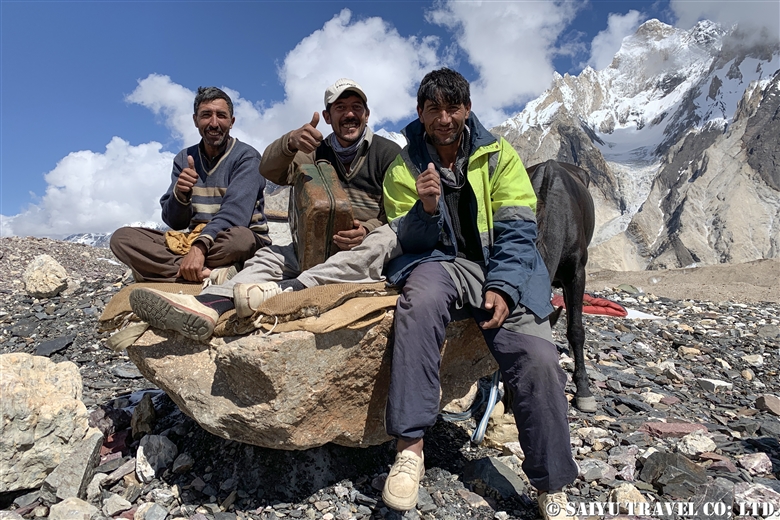
We finally fulfilled our long-cherished dream to climb Shatung Peak in the Deosai Plateau. That became possible only inn summer 2023, while in summer 2020 the tour was cancelled due to Covid -19 pandemic, when international flights were put to a halt. Overcoming the aftermath of pandemic and a tough route, we were able to reach the summit. We are tremendously grateful to our climbing guides and porters from Satpara village for their gracious support.

360-degree panoramic view from the summit. Feel like a high altitude climber!

From Chilas, we drove up to the Deosai Plateau through the Astor Valley. On the way, we were astonished by the view of  Nanga Parbat (8,126m), the 9th highest peak on the planet. On the Deosai Plateau, we camped by the beautiful Sheosar Lake, from where this majestic peak was visible. The lake is a very beautiful peaceful place, but sadly many local tourists were enjoining loud music until late at night. The next morning we entered an area with no other visitors in sight and found the original Deosai Plateau.

The first part of the climb was a relatively easy route, with patches of buttercups and primroses. Little did we know that a difficult scree slope was awaiting.

The mountain en route is dotted with lakes in a very beautiful valley. The snowy mountain in front is Shatung Peak, and we are aiming exactly there!

We walked through a patch of primrose to the camp. It was easy up to this point.

We arrived at Camp 1 on the scree slope. Now where shall we pitch our tents?

Sleeping on the snow is generally much more comfortable than sleeping on scree. Finally, we will challenge the summit early tomorrow morning!

The route from Camp 1 to the summit is this slope, covered with a mass of smaller loose stones. The climb is steep and strenuous.

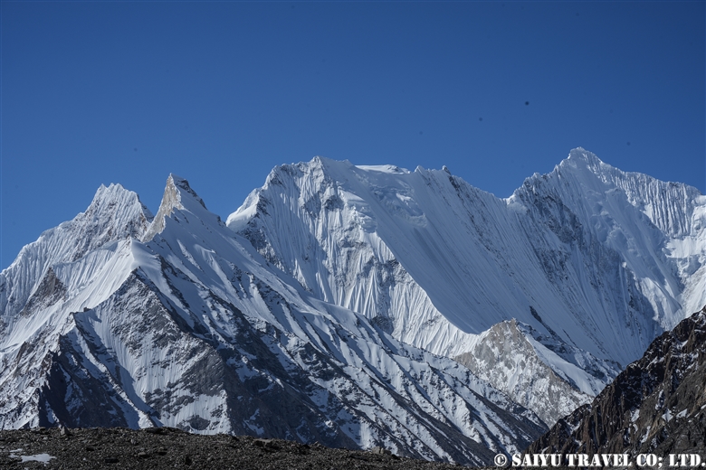
The view is spectacular when you stop and look back.

Beyond the mountains is Kashmir on the Indian side. Srinagar is also very close. The famous peaks of the Indian Himalaya, Nun peak and Kun Peak were also visible.

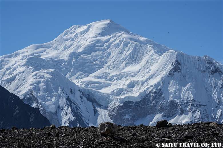
The world’s 9th highest peak, Nanga Parbat 8,126m, is on the left.

The steep climb up the scree slope is almost over. The ridge is getting closer.

Once on the ridge, all that remained was to climb up the snowy ridge. The sun was getting high in the sky.

We successfully climbed Shatung Peak (5,260m) with 5 core team members, guides, and porters! Nanga Parbat is in the background!

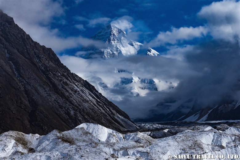
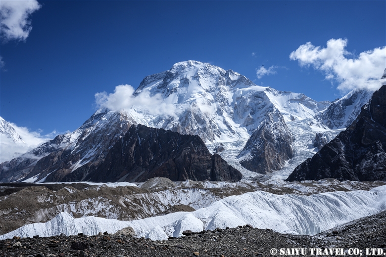
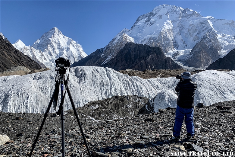
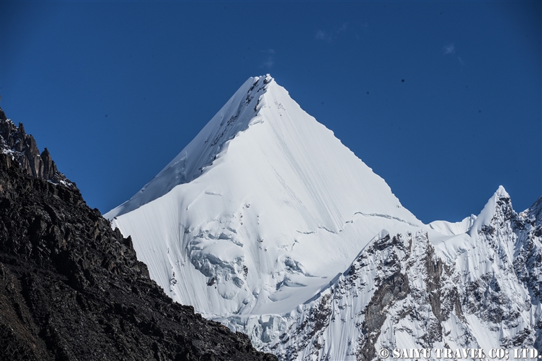
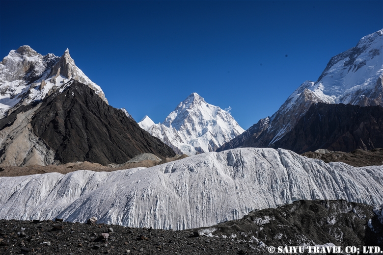
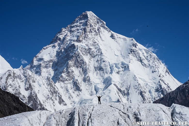
From the summit, we could see K2 and the Baltoro Mountains. From summit we could see all five of the 8,000 peaks in Pakistan: Nanga Parbat (8,126m), K2 (8,611m), Broad Peak (8,051m), Gasherbrum I (8,068m), and Gasherbrum II (8,034m). The weather was fine, with no wind. Forgetting about the steep scree slope that awaited us, we stayed at the summit for about an hour and enjoyed this blissful moment.


Image & text : Tomoaki TSUTSUMI

Tour conducted in July 2023, Deosai National Park, Gilgit-Baltistan

*Contact us, Indus Caravan for more information or to make arrangements for climbing Shatung Peak.

*Please follow us on YoutubeInstagram & Facebook

Category : - Nanga Parbat > ◆ Gilgit-Baltistan > - Deosai National Park > ◇ Mountain of Pakistan
Tag : , , , , , , , , , , , , ,

CONCORDIA 360 DEGREE

We stayed at Concordia on a truly cloudless, crystal clear morning in mid-June. The video was rattled by manual paaning, but I made a 360-degree mountain view video from Concordia.

CONCORDIA 360 DEGREE


Image by Mariko SAWADA

A big thank you to the the whole Baltoro Glacier trekking team for working with us!


Related article

Youtube : Our baltoro Trek in 1 Min !

K2 & Baltoro Glacier Trekking 2022 (Part 1) Skardu to Paiju

K2 & Baltoro Glacier Trekking 2022 (Part 2) Paiju to Khoburtse

K2 & Baltoro Glacier Trekking 2022 (Part 3) Khoburtse to Urdukas

K2 & Baltoro Trekking 2022 (Part 4) Urdukas to GoreⅡ

K2 & Baltoro Trekking 2022 (Part 5) GoreⅡ to Concordia

Staying in Concordia, surrounded by the high Peaks of the Karakorum: K2, Broad Peak, Gasherbrum Mountain Range

★★★★★

*Contact us, Indus Caravan for more information or to make arrangements for your Baltoro Glacier trek.

Category : - Baltoro Glacier & Concordia > = Video Clip Gilgit-Baltistan > - Baltoro Glacier & Concordia > ◆ Video Breathtaking Views of Pakistan > ◆ Gilgit-Baltistan > ◇ Mountain of Pakistan > - Karakorum Range
Tag : , , , , , , , , , , , , , , , , ,

Our Baltoro Trek in 1 min

Here’s a staff-centric video clip of our first post-pandemic Bartolo Glacier trek in June 2022! Well done to all the guides, kitchen staff, sardars, and porters who made the round trip to Concordia multiple times this season!

Our Baltoro Trek in 1 min

Image by  Mariko SAWADA

A big thank you to the the whole Baltoro Glacier trekking team for working with us!


Related article

Youtube : CONCORDIA 360 DEGREE

K2 & Baltoro Glacier Trekking 2022 (Part 1) Skardu to Paiju

K2 & Baltoro Glacier Trekking 2022 (Part 2) Paiju to Khoburtse

K2 & Baltoro Glacier Trekking 2022 (Part 3) Khoburtse to Urdukas

K2 & Baltoro Trekking 2022 (Part 4) Urdukas to GoreⅡ

K2 & Baltoro Trekking 2022 (Part 5) GoreⅡ to Concordia

Staying in Concordia, surrounded by the high Peaks of the Karakorum: K2, Broad Peak, Gasherbrum Mountain Range

★★★★★

*Contact us, Indus Caravan for more information or to make arrangements for your Baltoro Glacier trek.

Category : - Baltoro Glacier & Concordia > = Video Clip Gilgit-Baltistan > - Baltoro Glacier & Concordia > ◆ Video Breathtaking Views of Pakistan > ◆ Gilgit-Baltistan > ◇ Mountain of Pakistan
Tag : , , , , , , , , , , , , , , , , , ,

Staying in Concordia, surrounded by the high Peaks of the Karakorum: K2, Broad Peak, Gasherbrum Mountain Range

This is Concordia, The end of the Baltoro Glacier trek. It is a sought-after destination surrounded by 360 degrees of high peaks like K2.

In Latin, the word “Concordia” means “confluence and harmony,” and was given this name due to it being a confluence point between the Baltoro and Godwin-Austen Glacier. From here, climbers will set out for peaks like K2, Broad Peak, Gasherbrum Mountains Basecamp, and the Gondogoro La (Pass).

The first morning after our arrival in Concordia, the camp was covered with fresh snow. With patches of blue sky coming through and since the forecasted weather was clear, I took the opportunity for a photo op, since we made it all the way here.

K2 & Baltoro Glacier Trekking 2022 (Part 1) Skardu to Paiju

K2 & Baltoro Glacier Trekking 2022 (Part 2) Paiju to Khoburtse

K2 & Baltoro Glacier Trekking 2022 (Part 3) Khoburtse to Urdukas

K2 & Baltoro Trekking 2022 (Part 4) Urdukas to GoreⅡ

K2 & Baltoro Trekking 2022 (Part 5) GoreⅡ to Concordia

K2 emerges from the clouds, just beyond the campground. It was a moment I had eagerly anticipated, finally seeing the mountain break through the clouds.

The view of K2 got even better. At 8,611m it is the second highest mountain in the world, just after Everest. It is a majestic mountain.

This is Broad Peak (8,051m) which came into full view before K2. Broad Peak, as it is aptly named, has a wide peak. It is the 12th highest mountain in the world and is also the first mountain to be scaled for the 8,000m Summit Challenge.

Not a cloud in the sky. A short walk from the campsite, this was taken from a place where we could see Angel Sar (6,858m). Just east of here, we can see the Gasherbrum Group, and to the south, was Baltoro Kangri and Chogolisa.

Angel Sar (6,858m) is a beauty, just Northwest of K2.

Baltoro Kangri, as seen from Concordia. There are several peaks from west to east, and the highest is said to be 7,312m high.

Vigne Peak(6,195m)at left, Khumal Gri(6,851m) at right. Chogolisa (7,668m) is a flat peaked mountain, peeking from behind a wall of ice. Heading west through this valley is the famous Gondogoro-la (Pass), which leads to the Hushe Valley.

During the day, the porters relax at the campsite. They sing, dance and are just having fun. They spend the entire summer going from Askole to Concordia and Base Camp and back, never returning to their village until the end of the season. We have worked with this same crew for years, and I am so grateful to them.

The Balti people make a fried bread called ‘Prantha.’ Do they mean “pratha?” perhaps but, anyway it is a fried bread. When it’s freshly made, it is the best.

The commemorative photo spot is a must. On June 13, 2022, we arrived in Concordia, the first Baltoro Glacier trek made by Saiyu Travel since the Covid-19 Pandemic.

We are filled with appreciation to the guides, porters and for being able to get back to work. We were the second squad to reach the Concordia this season.

Since we are here, made time for Gamow Bag practice.

This year’s Concordia has a 4G network!  The 4G is provided by the SCO (a mobile company in the mountainous regions of Pakistan) you can pick it up from around Gore II and is being sent out from Concordia. Of course, the best part of this is that you can see the weather forecast!

The evening sunlight setting on Gasherbrum Ⅳ(7,925m). These peaks of the Gasherbrum mountain range rise over Concordia.

I grabbed a shot of K2 and Broad Peak, just before the moonrise.

On the third night, we could finally get a scene of the moon and starry sky over K2. The moonlight illuminates K2 just as it gets dark.

Mitre peak (6,010m) is to the south of the campsite. This is the moon rising, not the sunrise.

This is daybreak hitting the Gasherbrum Mountains.

Gasherbrum IV peak shoulders the dramatic sunrise.

Welcoming the sunrise at Concordia.

Today’s weather – Clear.

The fine weather continues, and there was plenty of time for the staff to get commemorative photos. Then it was time to say bye to K2 and leave.
It was like a dream, and we left Concordia the next day.

Image & Text: Mariko SAWADA
Trek Date: Mid-JUN 2022

*The altitudes and distances traveled from site to site that are listed, are based on our own measurements and GPS equipment. Please note that these may differ from other official books or reference materials.

*Contact us, Indus Caravan for more information or to make arrangements for your Baltoro Glacier trek.

Category : - Baltoro Glacier & Concordia > - Baltoro Glacier & Concordia > ◆ Gilgit-Baltistan > ◇ Mountain of Pakistan
Tag : , , , , , , , , , , , , , , , , , ,

K2 & Baltoro Trekking 2022 (Part 5) GoreⅡ to Concordia

Finally, we made it the leg of the hike to Concordia. The camp on the glacier of Gore II is cold (in June), so we made early preparations and left quickly.

K2 & Baltoro Glacier Trekking 2022 (Part 1) Skardu to Paiju

K2 & Baltoro Glacier Trekking 2022 (Part 2) Paiju to Khoburtse

K2 & Baltoro Glacier Trekking 2022 (Part 3) Khoburtse to Urdukas

K2 & Baltoro Trekking 2022 (Part 4) Urdukas to GoreⅡ

K2 & Baltoro Trekking 2022 (Part 5) GoreⅡ to Concordia

Staying in Concordia, surrounded by the high Peaks of the Karakorum: K2, Broad Peak, Gasherbrum Mountain Range

We walked about 6 km from Gore Ⅱ (altitude 4,271m) to the 4,400m point stopping for a light meal, and then walked an additional 7.5 km to the campsite of Concordia (4,596m). It is an exciting hike, as the mountains of Concordia get closer and closer with each turn.

Morning at the Gore II camp. It’s going to be a cloudy day today, but the weather forecast says it’s going to be sunny for the entire two days of our stay in Concordia, so I’d like to expect it to be pleasant. Even so, the Masherbrum (7,821m) that emerged between the clouds in the morning sun, was really exceptional.

The porters are in a hurry. The porters and mules who we have contracted to accompany us only upto Concordia, quickly take our luggage back down. The glacier is a very harsh environment for the animals, and it is not a place to stay any longer than necessary.

The exhaled white breath of the hard-working porters.

Leaving Masherbrum behind, we head out from Camp.

A horse with our luggage (not a mule, but a horse). This year, we just redesigned the Saiyu Travel and Indus Caravan logos on the khaki green duffle bag.

Our light meal while on the glacier.

From here, you can see the Muztagh Tower (7,273m), a mountain on the border with China to the north. The name “Muztagh” is often heard in this area, but it means “mountain of ice and snow” in the Turkic language.

The Gasherbrum Mountains get closer as we approach them.

The view of the peaks of the Gasherbrum Group just before reaching Concordia.

We have to go through the campground of the Pakistani Army which is totally littered with trash and the CNKP (Central Karakoram National Park).  Then we finally reached our destination for this leg of the trip, where we can relax a bit for the next 3 nights.

We set up the Kitchen Tent and Dining Tents with Miter Peak (6,010 m) as the backdrop. It started to snow on this first night.

At nightfall, I got one shot as the snowfall subsided. Broad Peak (8,051 m) and K2 (8,611 m) are covered with clouds and the snow covering the ground. I am so looking forward to tomorrow morning!


Photo & text : Mariko SAWADA

Trek date : Mid -JUN 2022

*The altitudes and distances traveled from site to site that are listed, are based on our own measurements and GPS equipment. Please note that these may differ from other official books or reference materials.

*Contact us, Indus Caravan for more information or to make arrangements for your Baltoro Glacier trek.

Category : - Baltoro Glacier & Concordia > - Baltoro Glacier & Concordia > ◆ Gilgit-Baltistan > ◇ Mountain of Pakistan
Tag : , , , , , , , , , , , , , , , , , ,

K2 & Baltoro Trekking 2022 (Part 4) Urdukas to GoreⅡ

Finally, the Baltoro Glacier camping is about to begin. Today, in a relatively short hike, we will walk from Urudukas (4,061 m) to Gore I (4,185 m), lunch, and then continue the hike to Gore II (4,271 m). Immediately after leaving Urdukas, we will enter the Baltoro Glacier and repeat many ups and downs to progress.

K2 & Baltoro Glacier Trekking 2022 (Part 1) Skardu to Paiju

K2 & Baltoro Glacier Trekking 2022 (Part 2) Paiju to Khoburtse

K2 & Baltoro Glacier Trekking 2022 (Part 3) Khoburtse to Urdukas

K2 & Baltoro Trekking 2022 (Part 4) Urdukas to GoreⅡ

K2 & Baltoro Trekking 2022 (Part 5) GoreⅡ to Concordia

Staying in Concordia, surrounded by the high Peaks of the Karakorum: K2, Broad Peak, Gasherbrum Mountain Range

The five kilometer journey between Gore I and Gore II is GIV (7,925 m) in front of Masherbrum (K1, 7,821 m ) to the south and Muztag Tower (7,273 m) to the north. So I got a few photos while trekking.

The view from the Urdukas camp in the morning. From Paiju Peak to Biale, it seems to be a comparison of the high peaks north of the Baltoro Glacier.

From the early morning, the porters and various expeditions started departing one after another. Our group is on the way to Gore II, but the expedition teams will go directly to Concordia or the base camp of the target mountain. For the porters, they just want to quickly carry it up and get back in order to take the next job.

Heading up to the Baltoro Glacier in a caravan of mules and porters.

As we climb, we sit on the boulders that are at the right height, for taking a break along the way.

As the glacier melts, the rocks crumble and from moment to moment the route changes.

We cross over several small rivers that have formed at the various breaks in the glacier.

Just ahead, GIV is getting closer and closer!

We have arrived at our lunch spot on Gore I (4,185m). It was a little too early lunch, so I just took a break.

It is exceptional to be able to sit on a Glacier for lunch on such a sunny day.

After lunch, the peak of Masherbrum (K1) is our guiding star.

The view of Masherbrum as seen from the Baltoro Glacier. With an altitude of 7,821 m, this is the 22nd highest mountain in the world, and in Pakistan, it is the 11th highest mountain. Masherbrum can be seen from the Baltoro Glacier, and can easily be climbed from the Hushe Valley on the south side.

Peak of Masherbrum (7,821 m). In 1856, the British army named this as the first peak of their Karakorum mountain survey, so it got the name K1.

With Masherbrum to our south, we kept making our way across the glacier to Gore II (4,271m).

From our campsite at Gore II, we could continue to enjoy our day of “Masherbrum watching” until dark.


Photos & Text: Mariko SAWADA
Trek Date: Early Jun, 2022

*The altitudes and distances traveled from site to site that are listed, are based on our own measurements and GPS equipment. Please note that these may differ from other official books or reference materials.

*Contact us, Indus Caravan for more information or to make arrangements for your Baltoro Glacier trek.

*Please follow us on YoutubeInstagram & Facebook

Category : - Baltoro Glacier & Concordia > - Baltoro Glacier & Concordia > ◆ Gilgit-Baltistan > ◇ Mountain of Pakistan
Tag : , , , , , , , , , , , , , , , , , , ,

K2 & Baltoro Glacier Trekking 2022 (Part 3) Khoburtse to Urdukas

Today we only travel about 7 km, from Khoburtse (3,834m) to the campsite in Urdukas (4,061m), which makes it a short day for trekking. Along the way, we cross two glaciers from the Urdukas Peaks, and from tonight we will finally begin camping at over 4,000 m.

K2 & Baltoro Glacier Trekking 2022 (Part 1) Skardu to Paiju

K2 & Baltoro Glacier Trekking 2022 (Part 2) Paiju to Khoburtse

K2 & Baltoro Glacier Trekking 2022 (Part 3) Khoburtse to Urdukas

K2 & Baltoro Trekking 2022 (Part 4) Urdukas to GoreⅡ

K2 & Baltoro Trekking 2022 (Part 5) GoreⅡ to Concordia

Staying in Concordia, surrounded by the high Peaks of the Karakorum: K2, Broad Peak, Gasherbrum Mountain Range

Shortly after leaving Khoburtse, we crossed the glacier from the Urdukas Peaks. The big boulders and rocks are scattered around us everywhere.

The mules are loaded down with climbing equipment, as one party passes by us one after another. When I asked the porter what is going on, he said that there are two expedition groups heading for Urdukas from Paiju. It seems the campsite will be crowded tonight.

A Balti porter who is drinking the glacier water. Throughout the trip, you will be amazed at their strength.

As we near Urdukas, the there is more vegetation, and the alpine plants were in bloom. For the rest of the trip, the campsites will all be on the glacier, so this is the last chance for the pack animals to eat fresh grass.

Even so, the flowers were in bloom near the campsite and those tough little mules were grazing on them. The mules kept arriving in droves, to eat the flowers and grass. The number of mules that arrived on this one day exceeded 200 head.

These flowers can typically be seen until early July. Not only flowers, but here, wild birds can also be seen as well. I will introduce just a few of the shots I got.

A Yellow-billed chough, Pyrrhocorax graculus. They are waiting patiently for the humans to leave the campsite with leftovers.

This is the Red-billed chough, Pyrrhocorax pyrrhocorax. They forage for nuts and insects, but here they were aiming for leftover food with the Yellow-billed choughs. Living in this harsh environment, anything we leave behind is such a treat! During the Baltoro Glacier trek, we tend to see more Yellow-billed choughs than the red-billed choughs.

In addition to the two wild crow family, which I just introduced, there is also the raven. This area’s ravens is a subspecies Corvus corax tibetanus (also Tibetan raven), which are the largest and most gorgeous raven species. From this campsite all the way to Concordia, you’ll see these three crows at every campsite along the way.

When I got this shot of the Red-fronted Rose finch, Carpodacus puniceus I was so excited. According to the distribution maps, it is a bird that lives in the high mountains around the Tibetan Plateau.

When we arrived at the campsite, we had it all to ourselves, but then soon after that, two other groups arrived one after another.

By the evening the campsite was bustling. One problem with the Urdukas campsite is that the permanent toilets are very far away. We only stayed for one night, but for groups that come from Paiju to Urdukas in one day, they tend to stay for two nights and take a full day of rest before continuing.

Today, the goat we had brought up with us was butchered, we were offered a fresh “charcoal-grilled liver” and the staff enjoyed a stewed dish of the organs. This goat meat was our source of food until the final day of our trek. By the way, the other group of climbers had brought yaks and dzo (or zho, which are yak-cow hybrids).

The view from the campsite in the evening. Baltoro Glacier with the Trango Castle and beyond that, Uri Biaho.

The west side of the Urdukas campsite just as the sun was setting. A part of the Urdukas Peaks appeared in the background, and moments later, the moon rose from here.

Photos & Text: Mariko SAWADA
Trek date: Early June 2022

*The altitudes and distances traveled from site to site that are listed, are based on our own measurements and GPS equipment. Please note that these may differ from other reference materials.

*Contact us, Indus Caravan for more information or to make arrangements for your Baltoro Glacier trek!

Category : - Baltoro Glacier & Concordia > - Baltoro Glacier & Concordia > ◆ Gilgit-Baltistan > ◇ Mountain of Pakistan > ◇ Birds of Pakistan
Tag : , , , , , , , , , , , , , , , , , , , , ,

K2 & Baltoro Glacier Trekking 2022 (Part 2) From Paiju to Khoburtse

Today is the journey from Paiju to Khoburtse. The route of the Baltoro Glacier changes every year, actually it changes constantly, because the glacier constantly moves and collapses, and the distance to travel changes, depending on that. This year we went near the middle of the glacier and climbed up to Moraine just before the Liligo camp.

K2 & Baltoro Glacier Trekking 2022 (Part 1) Skardu to Paiju

K2 & Baltoro Glacier Trekking 2022 (Part 2) Paiju to Khoburtse

K2 & Baltoro Glacier Trekking 2022 (Part 3) Khoburtse to Urdukas

K2 & Baltoro Trekking 2022 (Part 4) Urdukas to GoreⅡ

K2 & Baltoro Trekking 2022 (Part 5) GoreⅡ to Concordia

Staying in Concordia, surrounded by the high Peaks of the Karakorum: K2, Broad Peak, Gasherbrum Mountain Range

The journey is slow-going from Paiju, at an altitude of 3,420 m to Khoburtse, at an altitude of 3,834m. It is only a 15km in distance, but it takes a lot of adapting to the conditions and going carefully along. Most trekkers just head directly for Urdukas.

From the Paiju campsite, we walked north along the banks of Braldu River for 4 km and then hiked up the Baltoro Glacier.

The Braldu valley is formed by the water that flows out from the Glacier.

The Trango Towers in the background.

Great Trango Tower, 6,286m as seen from the Baltoro Glacier. The Trango Towers are famous for having one of the largest rocky cliffs in the world.

Breaktime!

The view after crossing Liligo. The Glacier and the Baltoro Cathedral and the Lobsang Spire just beyond it.

Arrived at the Khoburtse campsite. It is much smaller compared to the Paiju and Urdukas. There were no other guests so our group had the whole campsite to ourselves.

The Kitchen tent. Dinner usually starts at 6:30pm every day during trekking.

After dinner, the sunset from Khoburtse. The porters’ tents stayed lit. The clear skies over the mountains were beautiful.

On the left is Paiju Peak, and on the right is Uli Biaho.

The Khoburtse campsite is set right in the front of the Trango castle (on the right).
Tonight was another quiet night for us.


Photos & Text: Mariko SAWADA
Trek Date: Early June 2022

*The altitudes and distances traveled from site to site that are listed, are based on our own measurements and GPS equipment. Please note that these may differ from other official reference materials.

*Contact Indus Caravan for more information or to make arrangements for your Baltoro Glacier trek!

Category : - Baltoro Glacier & Concordia > - Baltoro Glacier & Concordia > ◆ Gilgit-Baltistan
Tag : , , , , , , , , , , , , , , ,

K2 & Baltoro Glacier Trekking 2022 (Part 1) From Skardu to Paiju

This is a record of the June 2022 Trekking, where we could lead our first Baltoro Glacier Trek for Saiyu Travel Japan since the start of the worldwide pandemic. The Jeep Road has changed a lot since the last 2019 tour. It used to stop at Askole, but now it has been extended between Jhola and Skam Tsok, with construction still being carried out here and there. Larger groups use the Jhola campsite, while smaller groups can also camp on the banks of the Braldu river along the way. (Note: The “Jeep Road” in Pakistan is a pretty rough road that can be traversed by the car models called Toyota Jeep, locally.)

K2 & Baltoro Glacier Trekking 2022 (Part 1) Skardu to Paiju

K2 & Baltoro Glacier Trekking 2022 (Part 2) Paiju to Khoburtse

K2 & Baltoro Glacier Trekking 2022 (Part 3) Khoburtse to Urdukas

K2 & Baltoro Trekking 2022 (Part 4) Urdukas to GoreⅡ

K2 & Baltoro Trekking 2022 (Part 5) GoreⅡ to Concordia

Staying in Concordia, surrounded by the high Peaks of the Karakorum: K2, Broad Peak, Gasherbrum Mountain Range

The big feature of this year’s Baltoro Trek is that many “climbing teams” who have been waiting for these past three years come to climb one after the other. Since the Baltoro area is so close to the Indian border, the security is tight and in addition to the visa required to enter Pakistan, people must also at the same time, obtain a “trekking” or “mountain climbing” visa. The group’s permissions are linked to this visa. We were required to submit an application and can only depart after the group’s approval. At the beginning of this season, the number of applications for this “trekking” and “mountain climbing” visa has increased sharply, so it took a considerable amount of time to obtain it. If you are planning trekking in the Baltoro area, be prepared to apply 45 days in advance.

K2 & Baltoro Glacier Trekking 2022

A car carrying our porters, who are heading to the first campsite. In June, the workload of the summit corps is quite heavy, so the porters, mules, and horses/donkeys are also quite busy.

While driving through the Shigar Valley, we passed through Hyderabad, the village where the driver lives. The driver’s wife brought us freshly harvested mulberries.

They were unbelievably sweet.

This is a photo taken near the village of Askole. Askole is also crowded with porters/unloaders for Baltoro Glacier trekking and is also famous for gem mining. The rock cave in this photo is the opening of the gem mining pit, which was also working at full swing.

From Askole, and beyond, this is the first jeep road to pass. Proceed along Braldu River which starts from the Baltoro Glacier. Along the way, there are so many steep ups and downs.

They have built a new bridge in Jhola, and after crossing it, a while later we saw the point where the construction of the road was still underway. Tonight’s campsite is on the riverbank, just a short walk from here.

The next day, we walked along the Braldu River. We will pass through the Skam Tsok campsite.

In front of us, stands the Baltoro Glacier, and on the sides partly covered by clouds the Trango Towers, the Baltoro Cathedral, and the Paiju campsite.

Paiju is a campsite abundant with water and greenery. The season had just begun, so the accommodation was fully reserved by our group.

While at the campsite, the porters were making Balti bread. This will be used as the food for the trekking on the glacier the next day.

Freshly baked bread.

This mule is in the middle of his meal. In the past, it was rare to see livestock being used in the trekking, but now it has become more mainstream to see them and horses and donkeys as well.

From tomorrow, they will get new horseshoes for the Glacier trek. It really feels like a new season has begun.

From the Paiju campsite, the mountains along the Baltoro Glacier, part of the Trango Towers on the left and in the middle, the Baltoro Cathedral. On the right are the Lobsang Spire.

Being the only ones staying overnight at the Paiju, it was a very quiet night.


Text & photo : Mariko SAWADA

Trek Date : Early JUN 2022

PS: In early July, the bridge 4 km from Askole was washed away by flood, so the trek has since been from Askole.

*Contact Indus Caravan for more information or to make arrangements for your Baltoro Glacier trek!

Category : - Baltoro Glacier & Concordia > - Baltoro Glacier & Concordia > ◆ Gilgit-Baltistan > ◇ Mountain of Pakistan
Tag : , , , , , , , , , , , , , , , , , , , , ,

Nanga Parbat (8,126m) As Seen From the Snowy Deosai Plateau

From the Deosai Plateau, there are several points where you can see the world’s 9th highest peak, Nanga Parbat (8,126m/26660 ft), but the best spot, is to descend from Sheosar Lake to the Astore valley, in my personal opinion.

It was quite a difficult undertaking, actually, but I aimed for a chance to get photos of Nanga Parbat from the snowy Lake Sheosar. First, we have to avoid travel the day after it snows on the Deosai Plateau because the road is impassable. Second, even if you make it to the Lake Sheosar, it must be a sunny clear day to see Nanga Parbat, so there really are not many days when you can have these perfect conditions.

Lake Sheosar surrounded by snow. This trip happened to be a day trip from Skardu, but it was quite difficult to travel on the snow-covered roads. Still, the scenery was rewarding when we reached it, and there was no one else there at that time.

When I looked to the west, Nanga Parbat appeared over the lake. Too bad, that the clouds were covering it a little, but still, we could make out the mountain just enough.

Heading down to Astore valley, you can see the entire mountain of Nanga Parbat. It is amazing that we can see this scene and get there by car.

Amin, our guide took a commemorative photo with Nanga Parbat. Due to the road conditions, on the way back, we cannot linger for long here. After observing flock of the Caspian gull and common coot on the Lake, we quickly headed back to Skardu.


Photo & text: Mariko SAWADA
Visit: Oct 2021, Shoesar Lake, Deosai National Park, Gilgit-Baltistan

Category : ◆ Gilgit-Baltistan > - Deosai National Park > ◇ Mountain of Pakistan > - Nanga Parbat / Himalaya Range
Tag : , , , , , , , , , , , , , , , ,